What/When:
Annual Seasonal Red Hind Closure
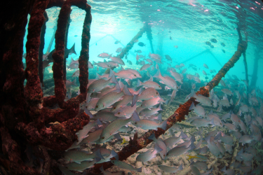
NOAA Fisheries reminds fishermen and the public of the annual seasonal closure on fishing for, or possession of, red hind grouper in federal waters west of 67° 10’ W longitude. This area is located off the west coast of Puerto Rico.
- The closure begins at 12:01 a.m., local time, on December 1, 2017, and extends through 11:59 p.m., local time, February 28, 2018.
Fishing Prohibitions in Red Hind Spawning Areas
From December 1 through February 28 each year, fishing for any species is prohibited in federal waters of the following red hind spawning aggregation areas:
- The Lang Bank red hind spawning aggregation area, east of St. Croix, U.S. Virgin Islands, bounded by the following coordinates:
A 17°50.2’ N 64°27.9’ W
B 17°50.1’ N 64°26.1’ W
C 17°49.2’ N 64°25.8’ W
D 17°48.6’ N 64°25.8’ W
E 17°48.1’ N 64°26.1’ W
F 17°47.5’ N 64°26.9’ W
A 17°50.2’ N 64°27.9’ W
- The Tourmaline Bank area closure off western Puerto Rico, bounded by the following coordinates (regulations only apply to the portion of Tourmaline Bank in federal waters):
A 18°11.2’ N 67°22.4’ W
B 18°11.2’ N 67°19.2’ W
C 18°08.2’ N 67°19.2’ W
D 18°08.2’ N 67°22.4’ W
A 18°11.2’ N 67°22.4’ W
- The Abrir La Sierra Bank area closure off western Puerto Rico, which lies completely within federal waters, and is bounded by the following coordinates:
A 18°06.5’ N 67°26.9’ W
B 18°06.5’ N 67°23.9’ W
C 18°03.5’ N 67°23.9’ W
D 18°03.5’ N 67°26.9’ W
A 18°06.5’ N 67°26.9’ W
Bajo de Sico Area Closure
Federal waters of the Bajo de Sico area off western Puerto Rico continue to be closed to fishing for and possession of reef fish managed by the Caribbean Fishery Management Council until March 31, 2018. Anchoring by fishing vessels is prohibited year-round.
Fishing and Anchoring Prohibitions within Hind Bank
Fishing for any species and anchoring by fishing vessels within the Hind Bank Marine Conservation District, south of St. Thomas, U.S. Virgin Islands, is prohibited year round. The Hind Bank Marine Conservation District is bounded by the following coordinates:
A 18°13.2’ N 65°06.0’ W
B 18°13.2’ N 64°59.0’ W
C 18°11.8’ N 64°59.0’ W
D 18°10.7’ N 65°06.0’ W
A 18°13.2’ N 65°06.0’ W
Why Are These Closures Happening:
These restrictions were developed to provide further protection for red hind spawning aggregations and large snappers and groupers, and to better protect the essential fish habitat where these species reside.
--------------------------------------------------------------------------------------------------------
Restricciones de temporada para la pesca en aguas federales del Caribe Estadounidense
FB17-072 SP
FECHA BOLETÍN DE PESCA: 30 de noviembre de 2017
Contact: Sarah Stephenson, 727-824-5305, sarah.stehenson@noaa.gov
QUÉ/CUÁNDO:
Temporada de veda del mero cabrilla
El Servicio Nacional de Pesquerías Marinas (NOAA Fisheries) le recuerda a los pescadores y al público en general sobre el comienzo de la temporada anual de veda para la pesca y posesión del mero cabrilla en las aguas federales al oeste de la longitud 67° 10’ O. Esta área está localizada en la costa oeste de Puerto Rico.
- La veda comienza a las 12:01 a.m., hora local, del 1ro de diciembre y se extiende hasta el 28 de febrero de 2018.
Prohibiciones de pesca en áreas de desove del mero cabrilla
Desde el 1ro de diciembre hasta el 28 de febrero de cada año, está prohibida la pesca de cualquier especie en las aguas federales de las siguientes áreas de desove del mero cabrilla:
- El “Lang Bank”, al este de Santa Cruz, Islas Vírgenes Estadounidenses, delimitado por las siguientes coordenadas:
A 17°50.2’ N 64°27.9’ W
B 17°50.1’ N 64°26.1’ W
C 17°49.2’ N 64°25.8’ W
D 17°48.6’ N 64°25.8’ W
E 17°48.1’ N 64°26.1’ W
F 17°47.5’ N 64°26.9’ W
A 17°50.2’ N 64°27.9’ W
- Tourmaline, en la costa oeste de Puerto Rico, delimitada por las siguientes coordenadas:
A 18°11.2’ N 67°22.4’ W
B 18°11.2’ N 67°19.2’ W
C 18°08.2’ N 67°19.2’ W
D 18°08.2’ N 67°22.4’ W
A 18°11.2’ N 67°22.4’ W
Las reglamentaciones aplican exclusivamente a la porción del Tourmaline que se encuentra en aguas federales.
- Abrir La Sierra o la “boya 6”, en la costa oeste de Puerto Rico, totalmente dentro de las aguas federales, delimitada por las siguientes coordenadas:
A 18°06.5’ N 67°26.9’ W
B 18°06.5’ N 67°23.9’ W
C 18°03.5’ N 67°23.9’ W
D 18°03.5’ N 67°26.9’ W
A 18°06.5’ N 67°26.9’ W
Área de Veda en el Bajo de Sico
Las aguas federales del Bajo de Sico en la costa oeste de Puerto Rico continuarán cerradas a la pesca de peces de arrecife manejados por el Consejo de Administración Pesquera del Caribe hasta el 31 de marzo de 2018. El anclaje de embarcaciones de pesca está prohibido durante todo el año.
Prohibiciones de Pesca y Anclaje en el Hind Bank
La pesca de cualquier especie y el anclaje de embarcaciones de pesca están prohibidos durante todo el año dentro del Distrito de Conservación Marina del “Hind Bank” (MCD, por sus siglas en inglés). El MCD se localiza al sur de San Tomás, en las Islas Vírgenes Estadounidenses y está delimitado por las siguientes coordenadas:
A 18°13.2’ N 65°06.0’ W
B 18°13.2’ N 64°59.0’ W
C 18°11.8’ N 64°59.0’ W
D 18°10.7’ N 65°06.0’ W
A 18°13.2’ N 65°06.0’ W
POR QUÉ ESTÁN OCURRIENDO ESTAS VEDAS:
Estas restricciones fueron desarrolladas para proveer mayor protección a las agregaciones de desove del mero cabrilla, las poblaciones de meros y pargos grandes y proteger mejor el hábitat esencial para peces donde estas especies habitan.
SIGN UP FOR TEXT MESSAGE ALERTS - FIND OUT ABOUT IMMEDIATE OPENINGS AND CLOSURES
NOAA's Text Message Alert Program allows you to receive important fishery-related alerts via text message (SMS). Standard message & data rates may apply. You may opt-out at any time.
Text alerts you may receive include:
- Immediate fishery openings and closures
- Any significant changes to fishing regulations that happen quickly
Sign up for one or more of the following groups:
- Gulf of Mexico Recreational Fisheries Related Alerts
- Text GULFRECFISH to 888777
- Gulf of Mexico Commercial Fisheries Related Alerts
- Text GULFCOMMFISH to 888777
- South Atlantic Recreational Fisheries Related Alerts
- Text SATLRECFISH to 888777
- South Atlantic Commercial Fisheries Related Alerts
- Text SATLCOMMFISH to 888777
- Caribbean Fisheries Related Alerts
- Text CARIBFISH to 888777