What/When:
Annual Seasonal Grouper Closure
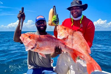
NOAA Fisheries reminds fishermen and the public of the upcoming seasonal closure on fishing for or possession of red, black, tiger, yellowfin, and yellowedge grouper in U.S. Caribbean federal waters.
- This closure begins at 12:01 a.m., local time, on February 1, 2017, and extends through April 30, 2017.
- This prohibition on possession does not apply to such grouper harvested and landed on shore prior to the closure.
Fishing Prohibitions in Grammanik Bank, U.S. Virgin Islands
NOAA Fisheries reminds fishermen and the public of the upcoming seasonal closure on fishing for or possession of any fish species, except highly migratory species, in the Grammanik Bank area off St. Thomas, U.S. Virgin Islands (Figure 1).
- This closure begins at 12:01 a.m., local time, on February 1, 2017, and extends through April 30, 2017.
- The term “fish” means finfish, mollusks, crustaceans, and all other forms of marine animal and plant life other than marine mammals and birds.
The Grammanik Bank area is located south of St. Thomas and bounded by the following coordinates:
| Point | Latitude North | Longitude West |
| A | 18°11.898' N | 64°56.328' W |
| B | 18°11.645' N | 64°56.225' W |
| C | 18°11.058' N | 64°57.810' W |
| D | 18°11.311' N | 64°57.913' W |
| A | 18°11.898' N | 64°56.328' W |

Figure 1. Map showing the Grammanik Bank area (shaded) off St. Thomas, U.S. Virgin Islands.
Why These Closures are Happening:
These seasonal closures protect species when they are spawning (reproducing) and therefore more vulnerable to fishing pressure.
Temporada de veda para la pesca y posesión del mero rojo, mero negro, tigre, guajil y guajil amarillo en las aguas federales del Caribe Estadounidense y Cierre de temporada en el Banco Grammanik en San Tomás, Islas Vírgenes Estadounidenses
FB17-003 SP
FECHA BOLETÍN DE PESCA: 18 de enero de 2017
Contacto: Sarah Stephenson, 727-824-5305, Sarah.Stephenson@noaa.gov
QUÉ/CUÁNDO:
Temporada de veda de meros
El Servicio Nacional de Pesquerías Marinas (NOAA Fisheries) le recuerda a los pescadores y al público sobre el comienzo de la temporada de veda para la pesca y posesión del mero rojo, mero negro (mero prieto), dientes de sable (tigre), guajil (mero pinto) y guajil amarillo en las aguas federales del Caribe Estadounidense.
- La veda comienza a las 12:01 a.m., hora local, del 1ro de febrero de 2017 y se extiende hasta el 30 de abril de 2017.
- La prohibición para la posesión de estos meros no aplica a aquellos meros capturados y desembarcados antes del tiempo de veda.
Prohibiciones de pesca en el Banco Grammanik en las Islas Vírgenes Estadounidenses
NOAA Fisheries le recuerda a los pescadores y al público sobre el comienzo de la veda a la pesca y posesión de cualquier especie de pez, excepto especies altamente migratorias (HMS, por sus siglas en inglés), dentro del área del Banco Grammanik, al sur de San Tomás, en las Islas Vírgenes Estadounidenses (Figura 1).
- La veda a la pesca comienza a las 12:01 a.m., hora local, el 1 de febrero de 2017, y se extiende hasta el 30 de abril de 2017.
El término “pez” se refiere a peces, moluscos, crustáceos, y cualquier otro animal marino y planta marina viva, aparte de aves y mamíferos marinos.
POR QUÉ ESTÁN OCURRIENDO ESTAS VEDAS:
Estas vedas protegen las especies durante su desove (reproducción), cuando son más vulnerables a la presión de la pesca.
El área de cierre del Banco Grammanik está enmarcada dentro de los puntos y las siguientes coordenadas:
| Punto | Latitud Norte | Longitud Oeste |
| A | 18°11.898’ N | 64°56.328’ O |
| B | 18°11.645’ N | 64°56.225’ O |
| C | 18°11.058’ N | 64°57.810’ O |
| D | 18°11.311’ N | 64°57.913’ O |
| A | 18°11.898’ N | 64°56.328’ O |

Figura 1. Mapa demarcando el área del Banco Grammanik (rectángulo A, B, C, D) en las Islas Vírgenes Estadounidenses.
NOAA Fisheries Southeast is pleased to announce the introduction of our Text Message Alert Program. The program will allow you to sign up to receive important fishery related alerts via text message. Text alerts you may receive include immediate fishery openings and closures, and any significant changes to fishing regulations that happen quickly.
How to opt-in:
Sign up for related alerts for one or more of the following groups. Standard message & data rates may apply. You may opt-out at any time.
- Gulf of Mexico Recreational Fisheries: Text GULFRECFISH to 888777
- Gulf of Mexico Commercial Fisheries: Text GULFCOMMFISH to 888777
- South Atlantic Recreational Fisheries: Text SATLRECFISH to 888777
- South Atlantic Commercial Fisheries: Text SATLCOMMFISH to 888777
- Caribbean Fisheries: Text CARIBFISH to 888777


