The Bering Strait separates Russia and Alaska at their closest point — a distance of around 53 miles. The Bering Strait’s eastern channel is larger than previously known, according to an analysis of a newly published seafloor map of the area. Scientists created the map by combining new high-quality depth data, older depth data, and digitized shorelines, to provide the first detailed shore-to-shore depiction of the strait. Overlapping newer and older depth information also showed that the channel seafloor had eroded by 1 meter between 1950 and 2010, most likely a result of strong currents.
Ocean waters travel from the Pacific to the Arctic through the Bering Strait, a narrow and shallow passage. The strait is small but plays a large role in bringing nutrient-rich Pacific waters to the ecosystems of the Chukchi Sea and western Arctic Ocean.
This northward flow of seasonally warm and fresh Pacific waters into the Arctic is important because it melts ice, lowers salinity, and regulates the climate by enhancing Arctic Ocean stratification—the natural separation of ocean water into horizontal layers by density.
Although sea surface height drives the overall northward flow, southerly winds can reverse the flow temporarily. “Wind is important in this tiny area,” said Mark Zimmermann, a research fish biologist at Alaska Fisheries Science Center. “The Pacific and the Arctic oceans have different sea levels, with Pacific waters believed to be around 0.5 to 1 meter higher in elevation than the Arctic waters.”
Gateway to the Arctic
The strait has an outsized role in the global circulation of ocean waters, linking the North Pacific Ocean to the North Atlantic Ocean. It is also the western end of the famed Northwest Passage, a maritime shortcut through the Arctic between Europe and Asia, unsuccessfully sought by Captain Cook in the summer of 1788.

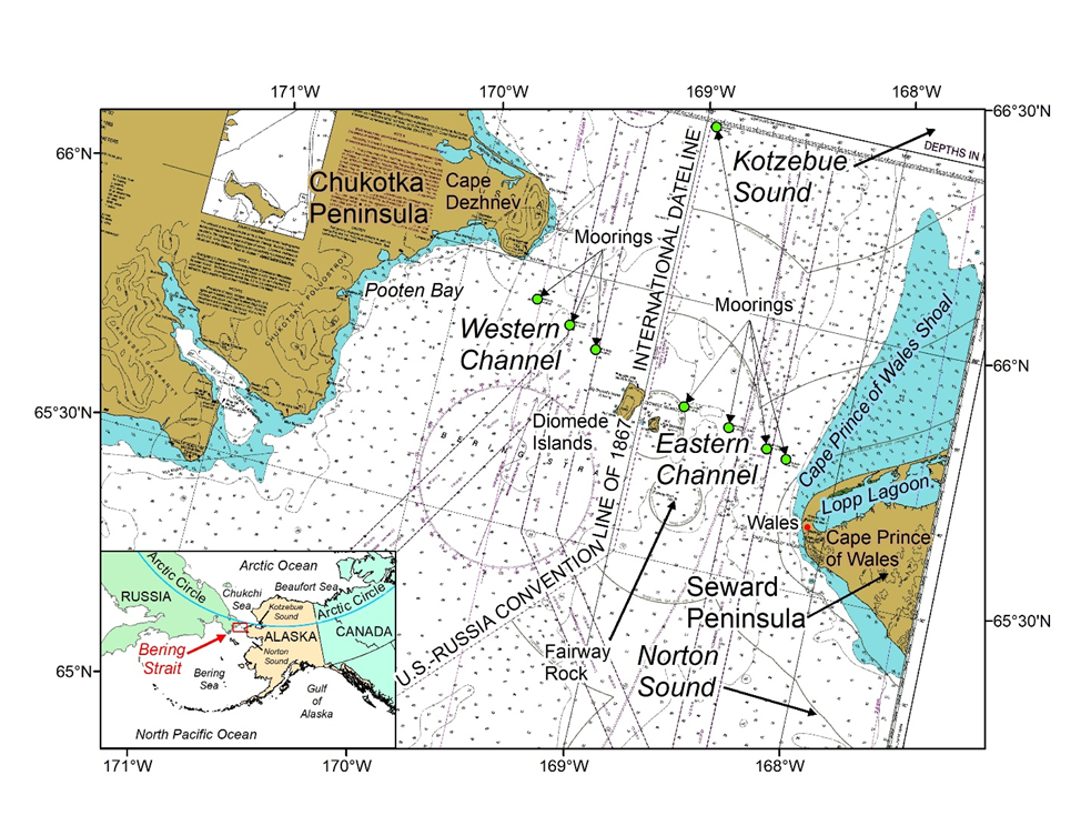
Sitting in the middle of the strait are the Diomede Islands, which split the passage into two main channels. The Big and Little Diomede Islands are roughly 4 kilometers apart but are separated by an international border, creating western (Russian) and eastern (U.S.) channels.
Due to the strait’s significance, year-round University of Washington moorings have monitored water flow since 1990. They are currently funded by the National Science Foundation’s Arctic Observing Network. These moorings are a collection of scientific devices attached to a chain anchored to the seafloor. Data from these moorings show a significant increase in net northward flow since the recordings began.
First Detailed Bathymetric Data of this Strait’s Eastern Channel
To help with understanding the volume of northward water flow, scientists created the first detailed shore-to-shore bathymetric, or depth, map of the strait’s eastern channel. They used that map to derive the narrowest point in the strait. Scientists use bathymetric data to show depths and shapes of underwater terrain.

Overlaps between newer and older bathymetric data sets identified areas of both erosion and deposition but showed that the majority of the eastern channel had eroded by 1 meter. “These changes in depth were relatively uniform within specific geographic areas, and made sense based on our understanding of the flow of water currents, but we did not conduct statistical tests on them owing to lack of measurement errors,” said Zimmermann. Supporting acoustic and sediment data shows that the seafloor has been swept clean of finer substrates due to the friction of strong currents.
These maps help define more recent depth changes and also reveal sediment changes over time. In the bathymetric image above, the orange area around Cape Prince of Wales Spit has a hardly discernible dark red line near to shore and running parallel to the spit. This seafloor feature, as indicated by the white arrow in the figure, is an offshore bar, a migrating hump of finer sediment previously known to occur in other Arctic areas.
Bathymetric evidence suggests that seafloor currents offshore of Cape Prince of Wales Spit and Shoal created areas of small and large seafloor waves of finer sediment. Black ovals in the map indicate these areas of sediment waves.
“Perhaps the most intriguing seafloor detail revealed in this research is a previously undescribed seafloor channel of unknown origin,” said Zimmermann. The southern end of this seafloor channel is near the western end of three larger seafloor channels extending out of nearby Norton Sound, suggesting a common origin: paleodrainages.
Paleodrainages are ancient channels in the landscape thought to have been formed by former rivers that were subsequently covered with modern sediments. In this case, scientists hypothesize that the Norton Sound paleodrainages may have been formed thousands of years ago by sudden, massive melting of ice age glaciers. At the time, much of this seafloor area was land (a land bridge connecting Asia to North America), exposed by lower ice-age sea levels.
Causes of Seafloor Erosion
Ice is another possible cause of sediment erosion. Floating ice sheets may have contributed to the erosion, but the seafloor being swept clean of small grain sizes is due to currents. Sea level change and land rise are other variables that could have caused these apparent changes in depth, but they are only small contributors.
“We conclude that the depth change over time has not caused the increasing currents. However, increasing currents and increasing strait size may be exacerbating an established trend of greater northward throughflow in recent decades with significant climate change implications,” said Zimmermann.
Oceanographers will now have a better definition of the strait and will be able to incorporate these data into their models. The next steps from this study would be to assemble a similar seafloor map for the area north of the strait that would include Kotzebue Sound and Chukchi Sea.
These maps and data are integral for scientists studying this area that is experiencing significant climate changes. “The seafloor maps that we have been producing have been used for defining numerous essential fish habitats, defining areas too rough and rocky for our bottom trawl surveys to sample, updating international, Arctic, and global seafloor maps, and understanding where to put acoustic instruments, moorings, to listen to whales or count fish,” said Zimmermann. “The Arctic is undergoing rapid climate change and defining the area will improve our ability to understand how this strait is changing and how it may change further in the future and how these changes may affect the marine life that use the strait or live around it.”