This fall, myself and 10 others set off on our annual North Atlantic Right Whale Shipboard Survey. Our goal was to collect data around groups of endangered North Atlantic right whales, including:
- Photo identification to monitor the population
- Drone imagery for behavior and health assessments
- Biopsy sampling for genetics and health metrics
- Suction cup tagging to get data on whale movements
- Plankton collection to sample their prey density
- Water sampling to measure dimethyl sulfide levels to see if they change with prey density and feeding
We surveyed a number of areas in the Northwest Atlantic Ocean that included south of Martha’s Vineyard and Nantucket, the Gulf of Maine, the northern edge of Georges Bank, Browns Bank, and the Bay of Fundy. Our home during the survey was an offshore supply ship M/V Captain Joseph E. Pearce. This is where we ate, slept, and conducted our research. During the survey, we scanned the horizon from dawn to dusk looking for marine mammals using high-powered binoculars. We looked for any signs of life—blows, bodies, splashes—and recorded the marine mammals we saw.
When we spotted whales, we’d launch our small boat, R/V Coriacea, from the back deck of the Pearce. We use the Coriacea to get closer to the whales and collect data. The back deck was also outfitted with two shipping containers. One was our science lab and the other stored our gear. We are completely set up for research!
This year, high winds kept us at the dock much of the time. We did get some lucky breaks when the weather and whale sightings aligned. Here are some notable highlights from our lucky breaks.
Right Whales in the Bay of Fundy

The Bay of Fundy is a critical habitat for right whales. Historically, aggregations were found here in summer and early fall. Around 2010, we started seeing a decline in sightings in the Bay. This was among the first signs that a major shift in right whale distribution was happening. During this year’s survey, our colleagues at the Department of Fisheries and Oceans Canada and Bar Harbor Whale Watch Company reported seeing right whales in the Bay! Their reporting guided our search and we spotted them at sunset on our first day.
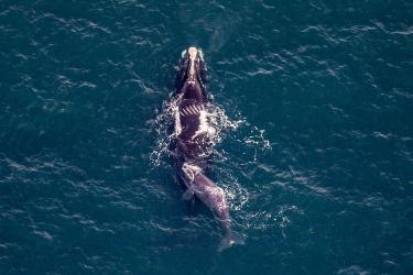
Muddy Whales and Surface Active Groups

Over 3 days we documented 21 different right whales and collected biopsy samples from four of them. While this is a fraction of the number of right whales once found here, it’s the highest number seen in years. We immediately got our drone up in the air to take some fantastic photos and videos.
Most of the whales we saw were in what we call “surface active groups.” Some of them had mud all over their heads! The Bay’s seafloor is covered in reddish, sticky mud. Clearly, the whales are diving all the way to the bottom for food. It’s incredible to see so many whales using the Bay again for feeding. Researchers who worked here in the heyday said it felt just like old times.
A Plethora of Plankton

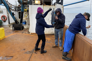
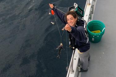
We collected plankton several times a day for analysis in the lab onshore. Some of our plankton tows were loaded with a zooplankton called Calanus—right whales’ favorite food. Sampling plankton at specific depths helps us learn what the whales are eating, how much is available for them to eat, and where in the water column they’re feeding. However, sometimes we didn’t find right whales where we found the most plankton. That’s why it’s important to sample in different areas.
We also used an instrument called a CTD to collect depth, temperature, and salinity data during each tow. We use the CTD to help us match environmental conditions with plankton species composition in the water column.
“Dog-ear” and Her New Calf

Roseway Basin is approximately 20 nautical miles south of Cape Sable Island, Nova Scotia, and is a critical habitat for right whales. Acoustic detections in that area had us heading over there where we found 10 right whales, including “Dog-ear” and her 2024 calf! This is extra special because her calf hasn’t been documented by any research team yet. We know that she’s a mom from an opportunistic sighting off Florida in February. Getting photos of the calf’s developing callosity is particularly important so that it can be identified in the future.

We returned to port with hard drives full of images and data, biopsy samples in the freezer, and so much plankton we ran out of jars to hold it. The survey was a success!