A team of NOAA biologists are just back from a field expedition where they spent time tagging endangered leatherback sea turtles. Biologists had the opportunity to capture and place satellite tags on leatherback sea turtles in North Carolina, Massachusetts, and the northeastern Gulf of Mexico. This gives us new data about the coastal habitat used by this species. It also gave us a better understanding of relationship between turtle movements and behavior and human activities.
The details of sea turtles’ lives can sometimes seem elusive, even as sophisticated technologies and analyses for studying these threatened and endangered animals continue to be developed and applied. A basic question for researchers remains: how best to get insight into the behavior of these animals without disrupting their activities and negatively impacting them? They regularly migrate hundreds of miles per year, typically only spend brief periods of time at the water’s surface, and weigh hundreds of pounds.
Some species of sea turtles are regular visitors to coastal waters, which makes them at least a little more approachable. But leatherback sea turtles - the largest of the sea turtle species - journey across an ocean and back can be a regular part of their yearly routine. Getting data on these animals can be more complicated.
Since 2017, NOAA Fisheries’ scientists and their colleagues have been working to discover where along the U.S. Atlantic and Gulf of Mexico coasts endangered leatherback sea turtles might regularly and predictably occur. While additional locations likely exist, so far three areas have been identified in the northeast Gulf of Mexico and along the coasts of North Carolina and Massachusetts. Leatherbacks are either concentrated there during migrations, or are resident during particular times of the year, which would increase the probability of encounters.
This predictability then allows researchers to identify the best times to go out on the water to spot for leatherbacks and, when spotted, attempt capture. “Sneaking up” on leatherbacks is very challenging. It involves trying to monitor the direction of turtle movement while underwater, timing between breaths, and the number of breaths taken. That allows researchers to anticipate when a turtle is just about to surface and place a net in front of it to safely capture and restrain it.

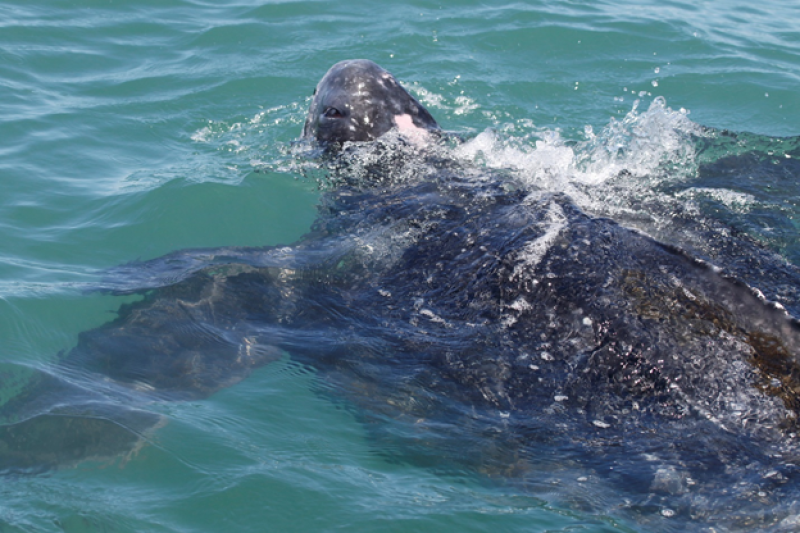
Once a leatherback is netted, it is carefully brought on board a small inflatable craft so that it can be photographed, measured, and outfitted with a satellite tag. The tag allows researchers to closely follow its movements and dive behavior. Blood and skin samples are taken to study the turtle’s health status and genetic origin. The turtle’s heart rate is also monitored to make sure that the turtle is not too stressed for tagging and sampling.
Turtles are also checked for tags to see if they have been captured in the past. The two types of tags usually applied are those attached to flippers and microchip tags like the ones used to identify lost pets. These tags display combinations of letters and numbers unique to individual turtles. If a turtle is not already carrying tags, then new tags are applied to make sure the turtle is recognized if it is sighted or captured in the future.

Tagged Turtle
A main focus of this leatherback research is to describe the turtles’ migratory routes, to anticipate potential conflicts between human activities and habitat use. Researchers are also interested in how long leatherbacks spend at the surface of the water at different times of year and at different locations. This makes it possible to estimate how often the turtles are visible to be counted during aerial surveys intended to document presence and estimate abundance.
After missing sampling seasons in 2020 due to the COVID-19 pandemic, NOAA researchers and collaborators were excited to be able to get back out on the water. In May 2021, they got back to the business of spotting and catching leatherbacks in coastal North Carolina.
This year however, they encountered conditions surprisingly different from those of previous years. There were record cold temperatures and almost constant high winds during the weeks the study was conducted. Biological observations reflected the difference in weather as well. There was a decrease in the number of potential leatherback prey, like jellyfish, and other fish species usually present. There was also an absence of leatherbacks in very nearshore waters where they would normally be found. These conditions were unusual, unexpected, and not those that typically facilitate leatherback capture. However, it was important for researchers to document the anomaly - it highlights the need to collect data over multiple years to capture this type of variability. Despite all of these challenges, the crew was able to successfully tag two turtles. Their tags are transmitting well and providing valuable information to compare and contrast with results from turtles tagged in previous years.
Researchers are looking forward to a busy rest of 2021. Additional captures and tagging is slated for the northern Gulf of Mexico and along the coast of Massachusetts later this year.
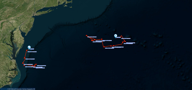
The red lines depict turtle movements over the course of 3 days. Thanks to our collaborators, which so far in 2021 have included Dr. Craig Harms (North Carolina State University College of Veterinary Medicine), Dr. Emily Christiansen (NC Aquariums), Dr. Matthew Godfrey (NC Wildlife Resource Commission), Samir Patel (Coonamessett Farm Foundation), and Mitchell Rider (University of Miami, RSMAS)
Support for the research is provided by the Bureau of Ocean and Energy Management and U.S. Navy as part of the Atlantic Marine Assessment Program for Protected Species. Work was conducted under a NOAA’s Endangered Species permit.