Following the Deepwater Horizon oil spill in April 2010, the Natural Resource Damage Assessment Trustee Council developed a monitoring and adaptive management framework. The framework allows us to evaluate the efficacy of various restoration activities, and adaptively manage ongoing and future projects to maximize restoration success. . While other partners and institutions lead many active restoration across the region, Southeast Fisheries Science Center scientists and their collaborators are experts in long-term monitoring of marine species in offshore oceanic waters. Here’s how our teams are involved in tracking the progress of these restoration efforts across the Gulf.
Looking for Marine Mammals

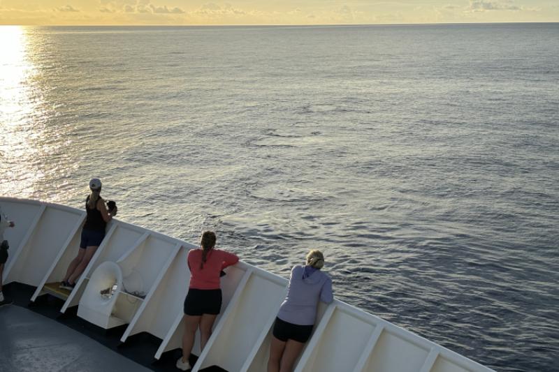
To effectively monitor the outcomes of marine mammal restoration in the Gulf, we needed reliable abundance and distribution data to analyze trends through time. One of the most effective ways to estimate offshore marine mammal abundance is through vessel-based visual surveys. The Southeast Fisheries Science Center partnered with other federal agencies and partners to conduct surveys in 2017–2018. We repeated these during the 2023–2024 project to evaluate trends in populations and changes in spatial distribution since the spill.
During these surveys, marine mammal observers look through giant binoculars searching for animals. Once they spot one, they identify the species, record behavior, determine the group size, and take photos. Our acoustic team simultaneously listens for and records marine mammal vocalizations using a towed array of hydrophones to help add to the data. Between the 2023–2024 surveys, the team recorded 1,139 marine mammal sightings and 476 acoustic detections, and covered 14,890 kilometers of tracklines!
See what it’s like to be on a marine mammal vessel survey
Listening for Marine Mammals
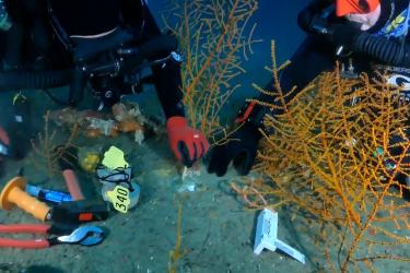
It is hard to continuously monitor whales and dolphins at sea, due to the remoteness of the environment and the cost and logistics of conducting uninterrupted shipboard or aircraft surveys. However, passive acoustic monitoring techniques can help to monitor vocalizing whales and dolphins in important and broader areas of the oceans day and night, seasonally, and across years, enabling filling critical gaps in our knowledge about cetacean distribution, call characteristics, and movement. Dr. Melissa Soldevilla, a senior bioacoustician at the center, along with Dr. Kaitlin Frasier at Scripps Institution of Oceanography, led an international team of researchers. They deployed long-term passive acoustic recording instruments throughout the Gulf to “listen” for vocalizing whales and dolphins for the last 15 years. The recorders are moored to the seafloor and capture sound from a variety of sources, including whale sounds.

During the original damage assessment, we began collecting passive acoustic recordings at five mooring sites. In 2020, this effort grew into a collaborative passive acoustic monitoring program to assess marine mammal populations in the Gulf of America. These data improve our understanding of noise impacts on marine mammal acoustic behavior, distribution, and movements, oceanographic processes, and the Gulf ecosystem. We use the data collected under the project to develop predictive habitat models to assess what processes drive trends in marine mammal spatial distribution and densities for up to 20 oceanic cetacean species throughout the Gulf. Combined with data on the soundscapes and human noise sources they experience, these models inform management and conservation actions for species recovering from Deepwater Horizon impacts.
By extending existing data collections and adding new sites throughout U.S. and Mexican waters of the Gulf, researchers are learning about long-term changes in marine mammal populations since the oil spill. The Gulf of America is one of the noisiest industrialized oceans in the world and thus, can have negative impacts on marine mammals that visualize their world through sound. Researchers are discovering new information about where species occur in the southern Gulf. They are also developing a better understanding of where adverse human noise sources (like vessel traffic, construction noise) overlap with marine mammal hotspots. Some of the most exciting findings include the detection of Rice’s whales in Mexican waters for the first time, and new information demonstrating their regular occurrence off Texas.
A Decade of Toothed Whale Declines
One of the most striking findings since the spill is evidence of severe declines in cetacean densities in the Gulf of America at several passive acoustic mooring sites. Using acoustics, scientists tracked density declines in toothed whales and dolphins over the decade following the spill. These declines include endangered sperm whales (up to 31 percent decline), beaked whales (up to 83 percent), and small delphinids (up to 43 percent). We also saw declines both within and outside of the surface oil footprint. Though not conclusively linked to the oil spill, the scale of these declines is consistent with declines predicted by the injury assessment models following the spill. In fact, these declines have exceeded and outlasted post-spill damage assessment predictions, suggesting that the offshore ecosystem impacts may have been larger than previously thought.
Learn more about Deepwater Horizon marine mammal restoration and monitoring
Learning More About Endangered Rice’s Whales
The endangered Rice’s whale, formerly known as Gulf of Mexico Bryde’s whale, was likely heavily impacted by the Deepwater Horizon oil spill. Scientists estimate that 48 percent of Rice’s whale habitat in the eastern Gulf was exposed to oil from the spill.
With support from NOAA’s RESTORE Science Program, we conducted a multi-year study with Scripps Institution of Oceanography and Florida International University. We developed a comprehensive ecological understanding of the endangered Rice's whale. In 2018 and 2019, we collected data on the physical, oceanographic, and biological features that may influence Rice’s whale distribution in the Gulf of America. We surveyed mostly within the species’ current core distribution area using a multifaceted approach to collect data, integrating:
- Animal photo-identification
- Kinematic (motion) and acoustic tagging
- Biological sampling of the whales and their potential prey
- Visual and passive acoustic monitoring
- Environmental measurements and prey distribution mapping
Our research has identified that Rice's whales make foraging dives near the sea floor, especially during the day. Like most animals, they are also selective predators, consuming prey with the highest energy content when available. These data helped us develop a model to identify what makes the best conditions for Rice’s whale habitat, and predict where else these whales occur.
We also used a special tag to understand the whales’ diving and movement behaviors, sounds, and environmental conditions.
Learn more about Rice’s whale trophic ecology
Evaluating the Cumulative Impacts of Multiple Stressors
Science center staff are also modeling the cumulative effects of multiple human-caused stressors on sperm whales and oceanic dolphins. This will help us better understand changes in reproduction and survival since the spill. We will use the models to guide monitoring and adaptive management activities in the future. As we refine these models by adding additional data, we will use them to estimate the effects of restoration actions on the injured stocks. This will enable better prioritization of potential restoration activities and evaluation of the effectiveness of completed and ongoing restoration activities.
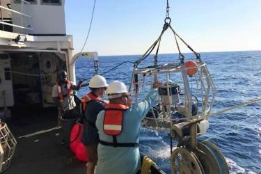
In summer 2025, the team plans to conduct a 65-day research expedition aboard NOAA Ship Gordon Gunter. The project will include deployment of telemetry tags on sperm whales to study their behavior and feeding as they dive to depths of up to 3,900 feet to find and feed on squids and other prey. We will use longer term tags to study their habitats and movements over periods of months. In addition to small boats, visual surveys, and passive acoustics, we will use drones to deploy tags and collect data on animal size and behavior using photographs and video. We will also start to expand our existing survey capabilities by integrating drones that can travel far from the ship to extend our visual monitoring. While this effort is focused on stocks injured by the oil spill, advanced technology will greatly increase data collection efficiency which can be used to quantify and assess marine mammal stocks in the future.
A Gulf-Wide Comprehensive Plan for Sea Turtle Data Collection

In the early days following the spill, scientists recognized that baseline abundance data were lacking for most sea turtle species. This highlighted the need for a strategy for collecting sea turtle data to which multiple collaborators across the Gulf could contribute. A team of scientists developed a statistically sound, comprehensive plan for coordinated, Gulf-wide collection and compilation of critical sea turtle data. This includes abundance, demographic, and biological information on all sizes and life stages of sea turtles.
In 2023, building on ongoing sea turtle studies, the Southeast Fisheries Science Center is championing a Sea Turtle In-Water Monitoring Network in the Gulf as the lead coordinating entity. The project team plans to engage with the sea turtle community and other Gulf researchers across the region to implement the plan through sharing resources and expertise.
Learn more about the In-Water Network sea turtle project
A Special Focus on Louisiana Sea Turtles
Louisiana waters, an important sea turtle habitat, were particularly impacted by the spill, but we needed data to inform restoration planning and evaluation in the region. The Southeast Fisheries Science Center initiated a restoration monitoring project to provide updated information on sea turtle habitat use and abundance in the area. Documenting sea turtle distribution and habitat use in Louisiana gives us a better understanding of how and where important habitats overlap with known threats and address key gaps in our knowledge of sea turtle movement ecology. Results from the work will help us plan and evaluate various restoration activities in the region.
“We can use these data to develop a predictive model for sea turtle species habitat use and distribution, in relation to physical and biological habitat characteristics,” said Dr. Sasso.
To measure this, the team is conducting six 10-day surveys in Lake Borgne and Chandeleur Sound. When they encounter a turtle, trained scientists collect health data and apply satellite and salinity tags to a subset of them to track their movements in relation to environmental parameters like changing water salinity levels. This allows the team to assess habitat use by overlaying satellite tracking data on available GIS habitat layers and remotely sensed environmental data like sea surface temperature, salinity, and productivity levels.
Learn more about sea turtle habitat use and abundance in eastern Louisiana waters
Advancing Surveys to Monitor Fish Abundance

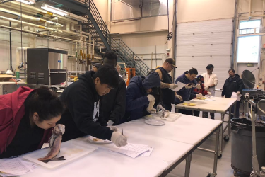
From 1992 to 2019, NOAA Fisheries and the Florida Fish and Wildlife Research Institute collected reef fish abundance data through three separate but similar surveys. The surveys deploy spherical cameras to the bottom of the ocean and record videos for a standardized amount of time to count fish. The surveys were limited in spatial coverage and sampling effort, and resulted in uncertainty in abundance indices. This was particularly evident when evaluating the impacts of the oil spill on reef fish populations.
“Fisheries-independent monitoring surveys are set up for long-term monitoring across a broad spatial scale—in this case, the entire Gulf,” said Dr. Matt Campbell, chief of the center’s Gulf and Caribbean Reef Fish Branch, and principal investigator on the project. “They were not set up to detect the specific impacts of these types of events within a smaller geographic area. It was clear that we needed more comprehensive sampling to detect impacts from environmental disturbances like oil spills.”
Following the spill, we brought together biologists from both agencies to ramp up survey efforts. But before getting started, we had to figure out where to sample. Scientists mapped 1,170,553 square kilometers of habitat from 10 meters to 200 meters deep. “Due to these mapping efforts, we expanded our sampling universe significantly, and the random design underlying the work ensures that it is spatially representative,” added Dr. Campbell. “Joining these efforts together allows us to do a ‘full court press’ in surveying reef fish across the Gulf, with the survey increasing from 600–700 sites sampled per year to about 2,000.” In the event of another spill, scientists will have a far better grasp on reef locations and better data to predict potential impacts.
Every year, our scientists analyze about 1,000 hours of footage collected from our 360-degree cameras. It’s a very time-consuming process, but it produces valuable data. The team began integrating artificial intelligence and machine learning to identify and count fish detected in our videos. These innovations will greatly increase the efficiency of data collection and processing. They will decrease analytical timeframes from more than a year to just a few months and improve our responsiveness when needs arise.
Integrating eDNA Into Fish Monitoring
We also integrated environmental DNA, or eDNA, metabarcoding to identify nearby species from water samples. We collect water samples containing DNA during the surveys, which allows us to compare what we see on video versus what DNA is detected in our sample. Analyzing eDNA is an efficient, non-invasive method for determining species present. It’s especially useful for detecting endangered, cryptic, or elusive species, and in places like the western Gulf where the lack of water clarity makes it difficult to identify species seen on video. “So far, we’ve collected 550 eDNA samples,” said Kate Overly, research fishery biologist contracted to the science center. “We’ve advanced our understanding and capabilities for integrating this method into our video surveys by making significant investments in our genomics library and sequencing. These advances, in combination with quantitative genomics methods, will help make our data collection more accurate, efficient, and comprehensive.”
These efforts have led to dramatically improved precision of fish abundance trends, and a stronger ability to understand the impacts of disturbances like oil spills. We’ve cut our variability (percent coefficient of variation) in half from about 20 percent to below 10 percent for target snapper-grouper species. Since its inception, the survey’s vital time-series data have directly supported 37 assessments for 20 species. By streamlining our video data collections, integrating advanced technology, and analyzing eDNA samples, we are making our data available more efficiently than ever. While the project is only 5 years old, it has quickly become the most comprehensive database for Gulf habitat and ecosystem resources available. It is a fundamental part of the Southeast survey enterprise.
Learn more about this survey project

More Science-Informed Restoration Ahead
While the science center has led a lot of work since the spill, along with numerous collaborators across the Nation and beyond, there is more work to be done.
“NOAA’s Southeast Fisheries Science Center and partners have conducted an immense amount of restoration work on a far-reaching scale—resulting in fish using rivers that were once devoid, corals spawning to create new substrate, increased comprehensive monitoring of sea turtles and marine mammals, expanded seagrass beds and marsh communities providing new habitat, among others,” summarized Jamie Monty, restoration coordinator for the center. “It's been humbling to be a small part of these successes, and exciting to think what the potential outcomes could be in another 15 years.”
We’re still incorporating knowledge from the early days of injury assessment and response into population and ecosystem assessments now and into the future. Active restoration will continue for decades to facilitate the recovery and resilience of impacted populations and ecosystems. Altogether, the strides we’ve made since Deepwater Horizon have shaped how we collect and analyze our data. It will also help us prepare for how to respond and adapt if another disaster strikes. Throughout these efforts, sustained monitoring is the only way to measure if restoration is effective at reaching our goals of a healthy and vibrant Gulf ecosystem, coastal community, and blue economy.
The projects described in this story are funded by the Deepwater Horizon Natural Resource Damage Assessment Trustees and the NOAA RESTORE Science Program.