Reducing Vessel Strikes to North Atlantic Right Whales
North Atlantic right whale vessel speed restrictions reduce the likelihood of lethal collisions between vessels and these endangered whales.
Right Whale Migration in an Urban Ocean
Endangered North Atlantic right whales are at heightened risk for vessel strikes because they spend a lot of time at or close to the water surface. Vessel strikes are a primary threat to the species.
Right whales can be very difficult to spot from a boat due to their dark color and lack of a dorsal fin. Poor weather and sea state or low light conditions can make spotting these whales nearly impossible.
This visualization illustrates the risk right whales face every day. It shows the migratory path of a 1-year-old right whale satellite-tagged off the Virginia/North Carolina coast in March 2021. The whale (red dot) traveled north along the Mid-Atlantic coast, overlapping with heavy vessel traffic (blue dots) and busy port entrances. In fact, the visualization shows only a portion of the actual vessel traffic—those vessels equipped with Automatic Identification Systems (AIS).
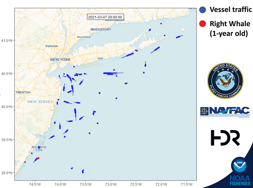
Whales can be quite challenging to tag. They are wild animals that do not always cooperate—their movements can be unpredictable and close approaches are risky even for trained, experienced responders. Researchers must wait for calm weather and the right moment to safely approach the whale. This whale’s tag lasted an impressive 16 days, one of the longer attachments the team has had on a right whale to date.
Experienced researchers at HDR Inc. tagged this right whale as part of a collaborative project involving the U.S. Fleet Forces Command and the Naval Facilities Engineering Services Command Atlantic. This tagging project is part of the U.S. Navy’s Marine Species Monitoring Program (NOAA Fisheries research permit #21482).
Proposed Modifications to Right Whale Speed Rule
NOAA Fisheries announced proposed changes to the North Atlantic right whale (Eubalaena glacialis) vessel speed rule to further reduce the likelihood of mortalities and serious injuries to endangered right whales from vessel collisions on July 29, 2022. NOAA Fisheries accepted public comment on the proposed rule until October 31, 2022.
NOAA Fisheries withdrew the proposed rule to amend the North Atlantic right whale vessel strike reduction rule on January 15, 2025. More information is available in the Federal Register notice.
Human impacts, including vessel strikes, continue to threaten the survival of North Atlantic right whales. NOAA Fisheries will continue to work closely with our partners and stakeholders to further efforts to conserve and rebuild the North Atlantic right whale population, including by using existing management measures and technological innovation and partnerships to help reduce the risk of vessel strikes.
- Supplemental materials
- All Boaters Should Reduce Their Speed to Protect North Atlantic Right Whales
- North Atlantic right whale Road to Recovery
Right Whale Speed Rule Assessment
In 2013, NOAA Fisheries committed to publish a report evaluating the conservation value and economic and navigational safety impacts of the 2008 North Atlantic right whale vessel speed regulations (50 CFR § 224.105). The report was finalized in June 2020 and evaluates four aspects of the right whale vessel speed rule: biological efficacy, mariner compliance, impacts to navigational safety, and economic cost to mariners. It also provides a detailed assessment of the rule’s effectiveness, and assesses general trends in vessel traffic characteristics within Seasonal Management Areas over time.
- Right Whale Vessel Speed Rule Assessment, June 2020 (PDF, 53 pages)
- Appendix A: Figures and Tables (PDF, 77 pages)
- Appendix B: Economic Impact Assessment (PDF, 87 pages)
NOAA Fisheries solicited public comment on the speed rule assessment. The comment period closed at the end of March 2021 and we are posting comments received for public reference.
- Public comments received on right whale speed rule assessment - March 2021(PDF, 592 pages)
- Southern Environmental Law Center and Oceana comment attachments (PDF, 1197 pages)
Current Vessel Speed Restrictions
Most vessels 65 feet or longer must travel at 10 knots or less in certain locations (called Seasonal Management Areas) along the U.S. East Coast at certain times of the year. This mandatory regulation reduces the likelihood of deaths and serious injuries to endangered North Atlantic right whales that result from collisions with vessels. Vessels of all sizes can strike a whale, so we encourage vessels less than 65 feet long to help protect right whales by slowing to 10 knots or less within these areas as well.
To monitor compliance with vessel speed regulations, we developed an interactive speed zone dashboard. Users can explore the dashboard to view vessel traffic by speed, season, month, speed zone, and vessel type.
- Compliance Guide (PDF, 2 pages)
- Final rule to eliminate sunset provision on speed restrictions (12/09/13, 78 FR 73726)
- Proposed rule to eliminate sunset provision on speed restrictions (06/06/2013, 78 FR 34024)
- Economic analysis of North Atlantic right whale ship strike reduction rule (2012, PDF 49 pages)
- Final rule to implement speed restrictions (10/10/2008, 73 FR 60173)
Seasonal Management Areas - Northeast

Cape Cod Bay, January 1–May 15
Includes all waters of Cape Cod Bay with Northern Boundary of 42º04'56.5"N, 070º12'W to 42º12'N, 070º12'W then due west back to shore.
Separate from the federal speed regulations in the Cape Cod Bay SMA, Massachusetts state law requires most vessels less than 65 feet to travel at 10 knots or less in the Cape Cod Bay Vessel Speed Restriction Area from March 1 to April 30. In 2025, the Massachusetts Division of Marine Fisheries (DMF) extended speed restrictions through May 15, 2025, due to the continued presence of right whales in Cape Cod Bay. Please visit the Massachusetts DMF website for information on state speed restrictions and advisories.
Off Race Point, March 1–April 30
Waters Bounded by:
42º04'56.5"N, 070º12'W
42º12'N, 070º12'W
42º12'N, 070º30'W
42º30'N, 070º30'W
42º30'N, 069º45'W
41º40'N, 069º45'W then due west back to shore.
Great South Channel, April 1–July 31
Waters Bounded by:
42º30'N, 069º45'W
42º30'N, 067º27'W
42º09'N, 067º08'24"W
41º00'N, 069º05'W
41º40'N, 069º45'W then back to starting point.
Seasonal Management Areas - Mid-Atlantic

Migratory Route and Calving Grounds, November 1–April 30
Block Island Sound waters bounded by:
40º51'53.7" N 070º36'44.9" W
41º20'14.1" N 070º49'44.1" W
41º04'16.7" N 071º51'21.0" W
40º35'56.5" N 071º38'25.1" W then back to starting point.
Within a 20-nm (37 km) radius of the following (as measured seaward from the COLREGS lines):
-Ports of New York/New Jersey:
40º29'42.2"N 073º55'57.6"W
-Entrance to the Delaware Bay
(Ports of Philadelphia and Wilmington):
38º52'27.4"N 075º01'32.1"W
-Entrance to the Chesapeake Bay
(Ports of Hampton Roads and Baltimore):
37º00'36.9"N 075º57'50.5"W
-Ports of Morehead City and Beaufort, NC: 34º41'32.0"N 076°40'08.3"W
Within a continuous area 20-nm from shore between Wilmington, North Carolina, to Brunswick, Georgia, bounded by the following:
A- 34º10'30"N, 077º49'12"W
B- 33º56'42"N, 077º31'30"W
C- 33º36'30"N, 077º47'06"W
D- 33º28'24"N, 078º32'30"W
E- 32º59'06"N, 078º50'18"W
F- 31º50'00"N, 080º33'12"W
G- 31º27'00"N, 080º51'36"W
and west back to the shore.
Seasonal Management Areas - Southeast

Calving and Nursery Grounds, November 15–April 15
Vessel speed is restricted in the area bounded to the north by latitude 31º27'N; to the south by latitude 29º45'N; to the east by longitude 080º51'36"W.
Right Whale Slow Zones and Dynamic Management Areas
Right Whale Slow Zones and Dynamic Management Areas (DMAs) are voluntary programs NOAA Fisheries uses to notify vessel operators to slow down to avoid right whales. Maintaining speeds of 10 knots or less can help protect right whales from vessel collisions. Under these programs, NOAA Fisheries provides maps and coordinates to vessel operators indicating areas where right whales have been detected. For a period of 15 days after a whale is detected, mariners are encouraged to avoid these areas or reduce speeds to 10 knots or less while transiting through these areas.
NOAA Fisheries establishes DMAs based on visual sightings of three or more right whales within a discrete area. Right Whale Slow Zones are based on both visual and acoustic triggers. They are identical to DMAs when triggered by right whale visual sightings.
NOAA Fisheries announces Right Whale Slow Zones and DMAs to mariners through our communication channels and lists zones below. The most recent designation is listed first.
All boaters from Maine to Virginia, or interested parties, can sign up for email or text notifications about the latest Right Whale Slow Zones. You can also follow us on Facebook (@NOAAFisheriesNEMA) and Twitter (@NOAAFish_GARFO) for announcements.
You can check for Right Whale Slow Zones on our online right whale sightings map. Or, you can download the free Whale Alert app, which will automatically notify you when you enter one of these areas.
Southwest of Martha’s Vineyard, MA DMA Slow Zone: Effective July 24 - August 8, 2025
Waters bounded by:
NORTHERN BOUNDARY: 41°20′ N
SOUTHERN BOUNDARY: 40°38′ N
EASTERN BOUNDARY: 070°43′ W
WESTERN BOUNDARY: 071°39′ W

Vessel Routing
Vessel routing recommendations to reduce collisions with North Atlantic right whales will soon be available on all NOAA Electronic Navigation Chart products.
Great South Channel Area to Be Avoided
For ships weighing 300 gross tons or more, a voluntary seasonal Area To Be Avoided (ATBA) is in effect each year from April 1 to July 31, when right whales face their highest risk of ship strikes in this area.
Boston, Massachusetts Traffic Separation Scheme
The North-South lanes of the Traffic Separation Scheme servicing Boston were narrowed from 2 miles to 1.5 miles (consistent with the East-West Boston Traffic Separation Scheme lanes) to reduce vessel collisions with whales.
Charts of Approaches to Boston Traffic Separation Scheme and Area to be Avoided
- 13200: Georges Bank and Nantucket Shoals
- 13203: Georges Bank Western Part
- 13006: West Quoddy Head to New York
Recommended Routes in Key Right Whale Habitats
NOAA established recommended vessel routes in four locations to reduce the likelihood of ship collisions in key right whale habitats in Massachusetts, Georgia, and Florida.
- Recommended routes (PDF, 2 pages)
Mandatory Ship Reporting System
When ships greater than 300 gross tons enter two key right whale habitats—one off the northeast U.S. and one off the southeast U.S.—they are required to report to a shore-based station.
In return, ships receive a message about right whales, their vulnerability to ship strikes, precautionary measures the ship can take to avoid hitting a whale, and locations of recent sightings.
Mandatory Ship Reporting System areas will soon be available on all NOAA Electronic Navigation Chart products.
- Mandatory ship reporting system placard (PDF, 2 pages)
- Final rule (11/20/2001, 69 FR 58066)
Report a Vessel Strike
Report vessel strikes to the National Marine Mammal Stranding Network.
Where Are Right Whales?
- Mapping application for right whale sightings in the North Atlantic Ocean
- Acoustic detections in Cape Cod Bay and the Boston TSS
- Download the Whale Alert app for iPad and iPhone