Web mapping app that displays and queries spatial data in the West Coast Region for Endangered Species Act ranges, critical habitat designations, and Magnuson-Stevens Act essential fish habitat. Users can generate a printable spatial query report.
We explore the potential for dynamic ocean management in an emerging hotspot of leatherback sea turtle bycatch in the New Zealand pelagic longline fishery.
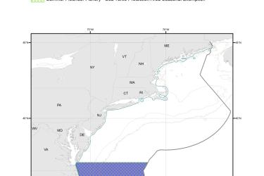
Map depicting where summer flounder trawlers in waters off Virginia (south of Cape Charles) and North Carolina must use an approved Turtle Excluder Device.
We generated high quality blood transcriptome assemblies for hawksbill (Eretmochelys imbricata), loggerhead (Caretta caretta), green (Chelonia mydas), and leatherback (Dermochelys coriacea) turtles.
We created a management strategy evaluation to compare static and dynamic closures in a simulated fishery, aimed at reducing bycatch of leatherback turtles.