Refine Results
Region
Management Areas
Map Type
Map Category
Topic
Species Category

Maps

457 resources match your filter criteria.

Great South Channel Restricted Area

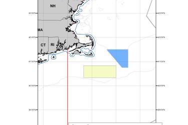
This dataset depicts the boundaries of the Great South Channel Restricted Area in effect from April 1 to June 30 annually in ESRI shapefile format for the NOAA Fisheries Service’s Greater Atlantic Regional Fisheries Office (GARFO).
August 01, 2022 - Map ,

Atlantic Sea Scallop Managed Waters Fishing Year 2022

This dataset depicts the boundaries of Atlantic Sea Scallop Managed Waters for Fishing Year 2022.
April 19, 2022 - Map ,
Scallop Wall Map 2022

Gillnet Closure Areas

This map includes the Nantucket Lightship Area and Closed Area I for gillnet closure areas.
October 21, 2021 - Map ,
Gillnet Closure Areas

Redfish Exemption Areas

This dataset depicts the boundaries of the Redfish Exemption Area, Redfish Exemption Area Cod Closure, and Redfish Exemption Area Seasonal Closure II. 
October 14, 2021 - Map ,

Social Indicators of Gentrification Pressure

How Gentrification is Affecting 29 Fishing Communities in the Northeast United States
May 26, 2021 - Map ,
Surf crashing on rocks.

Omnibus Deep-Sea Coral Amendment

Maps and GIS data representing Omnibus Deep-Sea Coral Amendment.
April 17, 2021 - Map ,

Herring Inshore Midwater Trawl Restricted Area

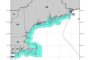
This dataset depicts the boundaries of the Inshore Midwater Trawl Restricted Area in ESRI shapefile format as described in Amendment 8 of the Atlantic Herring Fishery Management Plan.
February 16, 2021 - Map ,
Inshore Midwater Trawl Restricted Area Map

Alaska Groundfish Tagging Map

The National Marine Fisheries Service (NMFS) has been tagging and releasing groundfish in Alaska waters since 1972. In that time, approximately 452,000 tags have been released and over 36,000 have been recovered.
November 16, 2020 - Map ,

Cashes Ledge Groundfish Closure Area

Cashes Ledge Groundfish Closure Area is included in the Northeast Multispecies Closed Area Regulations for the Gulf of Maine.
October 01, 2020 - Map ,
Cashes Ledge Groundfish Closure Area. This map includes the Ammen Rock Area Habitat Management Area, Fippennies Ledge Habitat Management Area and the Cashes Ledge Closure Area and Cashes Ledge Habitat Management Area. Map created 7/23/2020.

Atlantic Chub Mackerel Management Unit

This dataset depicts the boundaries of the Atlantic Chub Mackerel Management Unit under a final Rule Implementing Amendment 21 to the Atlantic Mackerel, Squid, and Butterfish Fishery Management Plan.
August 04, 2020 - Map ,
Atlantic_Chub_map_2020622.jpg