This dataset depicts the boundaries of the South Island Restricted Area in effect annually from February 1-April 30 in ESRI shapefile format for the NOAA Fisheries’ Greater Atlantic Regional Fisheries Office (GARFO).
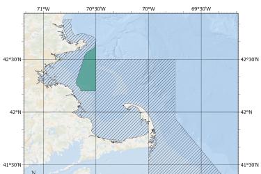
This dataset depicts the boundaries of the Massachusetts Restricted Area in effect annually from February 1 to April 30 in ESRI shapefile format for the NOAA Fisheries Service’s Greater Atlantic Regional Fisheries Office (GARFO).
This dataset depicts the boundaries of the Lobster Management Area One Restricted Area in effect annually from October 1 to January 31 in ESRI shapefile format for the NOAA Fisheries Service’s Greater Atlantic Regional Fisheries Office (GARFO).
This dataset depicts the boundaries of the Great South Channel Restricted Area in effect from April 1 to June 30 annually in ESRI shapefile format for the NOAA Fisheries Service’s Greater Atlantic Regional Fisheries Office (GARFO).
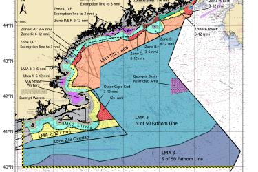
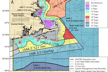
This map shows the minimum traps per trawl requirements for LMA 2 and LMA 3 put in place by the 2021 amendments to the Atlantic Large Whale Take Reduction Plan.
This map shows the new minimum traps per trawl requirements for New Hampshire fishermen put in place by the 2021 amendments to the Atlantic Large Whale Take Reduction Plan.
This map shows the new minimum traps per trawl requirements for Maine Zone G put in place by the 2021 amendments to the Atlantic Large Whale Take Reduction Plan.