After a year off from surveys in 2020 due to the pandemic, and strict staging protocols in 2021, it felt good to finally get back down to Lewes, Delaware. We got the R/V Hugh R. Sharp ready for the 2022 Atlantic sea scallop survey.
Shoreside Preparation
All aboard needed two negative COVID tests before they were cleared to sail. Seven scientific staff drove down 3 days before the vessel was set to sail, to “stage,” or set up, all the gear needed. Multiple days of setup and testing ensures everything is configured properly, to minimize the possibility of technical difficulties at sea.
Tasks included:
- Setting up the sampling van with three separate sampling stations
- Testing of our Habitat Mapping Camera (HabCam V4) vehicle
- Setting up the science lab with monitors, servers, and hard drives
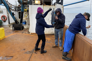
![An enclosed computer lab with overhead lighting on a research vessel. A dozen computer monitors are arrayed at multiple workstations. Thick cables are secured from the ceiling at left, and clusters of electronic equipment are placed around the work area. Two workers are at the center of the image, checking a monitor display.]()
Science Lab, R/V Hugh R. Sharp, 2022. Credit: NOAA Fisheries/Zachary Fyke

Cruise Gets Underway-Destination Mid-Atlantic
After a 2-hour delay caused by dense fog, we departed Lewes on May 14, 2022. This first leg of the survey was all about the HabCam. It's a towed camera array with two high-resolution cameras and four strobes, as well as many other scientific data collection instruments. The two cameras capture roughly six images per second. Technicians annotate some of these images to label finfish, shellfish, and human-made objects. Researchers use these images to estimate abundance of species like the Atlantic sea scallop and help to generate stock assessments, which are used to inform management decisions.

Once we got about 30 nautical miles offshore, we deployed the HabCam for a couple of test tows. After working out a few minor bugs, we re-deployed HabCam and headed to our first point on our trackline. Over the next 2 days, we worked our way over 200 nautical miles along our predetermined path.
On the night of May 15 we were lucky enough to see the lunar eclipse and blood moon with zero cloud coverage.

Over the next 4 days, we completed another 600 nautical miles, bringing our total to just a little more than 800. We’ve had great weather so far on our trip, with relatively calm seas. The greatest wave height we encountered was 6 feet, but in a 146-foot vessel you barely feel it. After finishing our tracklines in the Mid-Atlantic, we retrieved HabCam from the water and began a 12-hour steam northeast toward Nantucket Shoals.
Among my favorite sights at sea are the sunsets and sunrises unobstructed by human construction. The sunset on the sixth night was my favorite, because as the sun dipped down towards the horizon, a low fog layer made it appear purple to the naked eye.

Nantucket Shoals
On the night of May 19, we reached our new trackline southeast of Nantucket. Once we’d deployed and tested HabCam, we began working our way along our trackline.
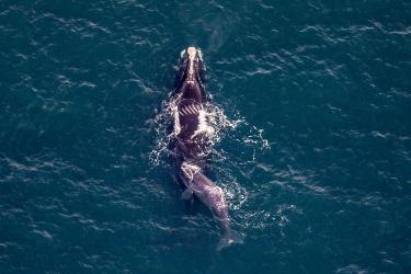
Because of the larger number of fish in the area, we saw more diversity of marine mammals and seabirds. On the screen that displays data from a forward-facing sonar, a dark shape would occasionally dart across the screen. These were likely common dolphins, which coast alongside and under the bow of the ship, riding in the draft that is created as the vessel cuts through the waves. We also saw humpback whales and even a basking shark!

Over the final 3 days of the survey, we completed more than 300 nautical miles, resulting in more than 1,125 miles covered and 3.35 million images taken. Of these images, the scientific crew on board annotated more than 50,000, which is a new all-time record!
We could not be prouder of the scientific staff that sailed on this first leg of the sea scallop survey. Working to ensure that COVID-19 was not brought aboard while staying engaged and working together through 10 days of “HabCamming” was no easy feat.
“The sea, once it casts its spell, holds one in its net of wonder forever.” – Jacques Cousteau
Zachary Fyke
On Leg 1, May 14-23, 2022
Aboard the R/V Hugh R. Sharp