Who We Are

The Oceanic and Coastal Pelagics Branch is a unit of the Population and Ecosystems Monitoring Division within the Southeast Fisheries Science Center. It was established in 2021 as part of the Southeast Fisheries Science Center’s organizational realignment. We are composed of scientists with considerable experience studying highly migratory species such as billfish, tunas, and sharks, as well as benthic survey-focused biota like snappers, groupers, and tilefish. We also study ecosystems and issues surrounding the conservation and management of many of these species.
Our scientists lead programs which provide critical data to the Southeast Data, Assessment, and Review process for sharks and reef fish. We also provide information to the International Commission for the Conservation of Atlantic Tunas (ICCAT) for billfish, tunas, and sharks. Our surveys and research support science needs of the Center and client partners, including:

- Southeast Regional Office
- Atlantic Highly Migratory Species Management
- ICCAT
- Regional fisheries management councils
Our scientists also provide oversight to regional survey programs and internationally recognized scientific journals.
Our Mission
Our overarching mission is to provide sound data and research products to support effective management of oceanic and coastal pelagic fishery stocks and survey-focused species in the southeastern U.S., including the Gulf of America (formerly Gulf of Mexico), U.S. Caribbean, and Atlantic high seas. Effective management includes promoting healthy, sustainable populations from both an economic and ecological perspective, supported by an enhanced understanding of ecosystem interactions.
Primary Programs

Bottom Longline Survey
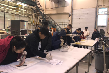
The Center’s Bottom Longline Survey has conducted annual sampling of continental shelf waters from Cape Hatteras, North Carolina, to the United States-Mexico border in the Gulf of America since 1995. This survey provides vital data for managed shark species and a variety of reef fish, including red snapper, groupers, and tilefish. Data from the survey have been used in the base model for 22 assessments for fishery stocks and species complexes. The survey lead is Dr. Trey Driggers.
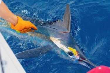
Cooperative Tagging Center
The Cooperative Tagging Center is the longest running tagging program for Highly Migratory Species and one of NOAA’s longest-lived citizen science projects. Since 1954, recreational anglers and commercial fishers throughout the Atlantic Ocean, including the Gulf of America and Caribbean Sea, have deployed more than 265,000 conventional tags on tunas, billfish, and swordfish. The Center’s tagging data are submitted annually to ICCAT to inform international stock assessments and are a key component in defining Essential Fish Habitat domestically. The Cooperative Tagging Center is managed by Eric Orbesen and Derke Snodgrass.

Core Activities
Our scientists continue to lead research using popup satellite archival transmitting (PSAT) and other satellite-linked tags to track fine-scale movements of target species and obtain a better understanding of habitat use and environmental preferences. Project leads coordinate with survey managers and volunteer anglers for field efforts to deploy tags on billfish, tunas, sharks and rays. Data obtained from those tags are then validated and analyzed to estimate discrete daily geolocations of the fish and determine water temperatures and depths inhabited by the fish. These data are often recorded on the frequency of minutes.

Research using electronic tags advances our understanding of:
- Movements
- Migration patterns
- Habitat use
- Population stock structure
- Post-release mortality rates associated with different fishing techniques
In addition to conducting surveys and research, we support the SouthEast Area Monitoring and Assessment Program. The program is a federal, state, and university cooperative initiative for the collection, management, and dissemination of fishery-independent data in the Gulf of America, U.S. Caribbean, and U.S. South Atlantic regions. Our scientists serve as Program Managers, Technical Monitors, and NOAA Representatives for the program. Team members from our branch also serve as Editors-in-Chief for the scientific journals Fishery Bulletin and Bulletin of Marine Science.
Fishery Bulletin, an official publication of the U.S. government since 1881, is one of the oldest and most respected international fisheries journals in the world. Bulletin of Marine Science, a University of Miami publication since 1951, is a hybrid open-access, quarterly journal dedicated to the dissemination of research in diverse disciplines, such as marine biology and ecology, fisheries, aquaculture, and socioeconomics.