U.S. AMLR Program 2024–25 South Shetland Islands Survey Field Team:
- Dr. Douglas Krause, Program Lead and Head of Pinniped Studies, NMFS/SWFSC
- Dr. Jefferson Hinke, Head of Seabird Studies, NMFS/SWFSC
- Samuel Woodman, Research Biologist, NMFS/SWFSC
- Jaelyn Leslie, Biological Science Technician, NMFS/SWFSC
Survey Report: January 2 – 11, 2025
Background:
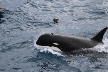
Every year since 1986, the United States Antarctic Marine Living Resources Program (U.S. AMLR Program) has conducted a suite of monitoring studies focused on Antarctic krill and krill-dependent predators in the northern Antarctic Peninsula. In recent decades, there have been dramatic changes in the population dynamics of krill predators, including brush-tailed penguins (gentoo, chinstrap, and Adélie penguins) and South Shetland Antarctic fur seals (SSAFS). SSAFS, in particular, are in a precipitous population decline with potential losses over 94 percent in the last 20 years. However, due to their extremely remote breeding locations, a survey of the South Shetland Islands has not been conducted since 2008, and a complete survey has not been completed since 2002.
Additionally, the global zoonotic (i.e., a disease that can be transmitted from animals to humans) caused by Highly Pathogenic Avian Influenza (HPAI) has killed millions of seabirds, and hundreds of thousands of marine mammals worldwide. During 2024, HPAI was observed in Antarctica, a continent with some of the largest concentrations of seabirds and pinnipeds in the world. Therefore, there is an urgent need for monitoring these populations.
From January 2 – 10, 2025, a team of U.S. AMLR Program scientists aboard the M/Y Hanse Explorer circumnavigated the South Shetland Islands and conducted ground and drone surveys of major penguin and SSAFS breeding colonies. Because of the catastrophic decline of SSAFS in the region, their breeding locations were prioritized. The team included Drs. Jefferson Hinke and Douglas Krause, Samuel Woodman, and Jaelyn Leslie. The following is a summary of the challenges and accomplishments of this survey. Final analyses of animal counts and HPAI samples are pending.
January 2, 2025: Embarkation
The NMFS/SWFSC team flew from Punta Arenas, Chile, to Frei Base (a Chilean research station) on King George Island in the early afternoon in clear conditions. After a smooth transition down to Maxwell Bay, we boarded the M/Y Hanse Explorer at approximately 4:00 p.m. local time. Following some planning meetings between the Captain, the Expedition Leader, and the U.S. AMLR team departed the anchorage for the first scientific goal of the cruise: to recover an autonomous oceanographic glider that had recently completed a krill biomass survey of the Bransfield Strait (for details see Copacabana Situation Report 1). Once the glider was secure, the ship transited to Cape Shirreff, Livingston Island.
January 3, 2025: Cape Shirreff personnel and cargo swap
The ship moored in a bay off of English Strait through the night, and departed at approximately 5:30 a.m. for Cape Shirreff. The ship arrived at the Cape at approximately 11:00 a.m. and immediately began Zodiac operations. All hands fell to transferring personnel and cargo ashore and aboard. Our colleagues LT Eric Fritzsche (NOAA Corps) and Justin Dye (Bespoke Project Solutions) went ashore to complete construction projects at the Holt Watters field camp at Cape Shirreff, and Samuel Woodman and Jaelyn Leslie came aboard along with supplies for Copacabana field camp. Operations were completed at approximately 12:30 p.m., and due to inclement weather, the ship returned to anchor in Maxwell Bay, King George Island.
January 4, 2025: Copacabana and False Round Point
None of the target SSAFS breeding sites were accessible due to weather conditions. Therefore, we started the morning by dropping off gear and supplies at the U.S. AMLR Program’s Copacabana field camp on King George Island. Zodiacs departed the ship at approximately 9:00 a.m. Due to a slight swell, the boats and gear were landed approximately a quarter mile north of the camp and moved with carts and by hand to the camp. All hands participated.
The ship then transited around to the north side of King George Island to attempt a landing at False Round Point. Due to the poor charting information available on the north side of the island, the ship approached directly from the north, and deployed the Zodiac approximately 5 nautical miles from False Round Point, where the largest chinstrap penguin breeding colony in the region is historically located. The Zodiac run was smooth despite the low (approximately half-mile) visibility.
The Zodiac landed on a northeast cobble beach, which had several small groups of elephant and Weddell seals. While Jefferson, Doug, and Jaelyn hiked up to the plateau to conduct a drone survey of the chinstrap penguin colonies, Sam and Ian walked the beach. Seven samples of animals and the environment were taken to test for HPAI; however, no signs of HPAI were detected on the beach or in the colonies. Surprisingly, Ian and Sam observed three SSAFS pups along the beach! This location had not previously been reported as a breeding site for SSAFS. Several hundred gentoo penguins were also observed breeding at the site.

January 5, 2025: Stigant Point
After sheltering from a northwest storm by steaming around the south side of King George Island, the ship arrived at Stigant Point at 10:00 a.m. Conditions were marginal to poor (3-4 m swell), but the forecast indicated improvements. We loaded into a Zodiac approximately 1.5 miles north of the Point. Suffice it to say, conditions did not improve. The swell actually increased substantially to 4-6 m. It was not safe to approach the shoreline, so after 30 minutes of exploration, we returned to the ship. However, due to the worsening swell, it was not possible to recover the Zodiac. Both ship and Zodiac sailed an additional four miles to a nearby tabular iceberg, which provided some lee. We were then able to board the ship and recover the Zodiac safely. The weather was forecast to deteriorate substantially, so the ship steamed south to the Antarctic Peninsula to find shelter.
January 6, 2025: Charcot Cove
Overnight on January 5, the ship holed up in Charcot Cove along the northern part of the peninsula. It turned out to be a good strategy because those vessels that remained at King George Island experienced winds up to 80 knots! Weather in the South Shetland Islands continued to be poor through January 6.
January 7, 2025: Admiralty Bay
Due to heavy weather between King George Island and Elephant Island, our next target destination, the ship dropped us at Copacabana at 9:00 a.m. and anchored nearby. We removed window covers, tested all heaters and the VHF base station and completed some basic cleaning tasks. The ship picked us up just after 12:00 p.m., and went back to anchor until 6:30 p.m., when the ship departed for Cape Valentine on Elephant Island.
January 8, 2025: Elephant Island Sites
Cape Valentine
The Zodiac departed the ship at 7:40 a.m., scouted the southern shoreline of Cape Valentine, and then dropped us off on an intertidal rock in the middle of the two SSAFS colony areas on the eastern shore. Doug went north, Sam and Jaelyn went south, and Jefferson found a spot to fly the drone. As an eminent penguin biologist, Jefferson initially struggled to locate the SSAFS breeding areas because, unlike penguins, they don’t heavily stain their surroundings with their own feces; however, the pups clearly won him over because he obtained fantastic drone coverage at every site in some truly challenging conditions. The beaches at Cape Valentine were narrow with steep rocky cliffs. While we moved ashore, Ian (EYOS Expeditions) and Arco (M/Y Hanse Explorer) surveyed the coast all the way south to the glacier and saw no SSAFS females or pups. The survey was completed by approximately 9:00 a.m. The swell was approximately 2-3 m from the south, and the weather was calm and foggy.
Seal Island / Rocks
The Zodiac departed the ship at 12:20 p.m. at an anchorage 1.3 nautical miles from the eastern terminus of Seal Island. Since he hadn’t visited the area in over 20 years, some extra exploration of the coast was needed before Doug got reoriented to the island, but eventually he located the landing area. Because of the north swell, the Zodiac dropped us off at 1:10 p.m. on the northeast side of the island, near North Cove. Jaelyn, Sam, and Doug sequentially walked through North Cove, North Annex, and Big Boote breeding areas, making independent counts of SSAFS pups. No signs of HPAI or dead animals were observed. Jefferson flew a drone to get coverage of SSAFS breeding beaches, penguins, and some orientation / reference video. We also observed dozens of macaroni penguins, including some active nests. While we were working at Seal Island, Ian and Arco circumnavigated Large Leap Island and saw only two juvenile SSAFS, and no females or pups. We boarded the Zodiac at 2:00 p.m. and returned to the ship after driving by the southern beach where the U.S. AMLR Program operated a field camp between the late 1980s and 1995.

Cape Lindsey
We launched the Zodiac at 5:45 p.m. and sailed to Cape Lindsey, a dark, spire-forward, gothic peninsula on the northwest coast of Elephant Island. Think Dr. Seuss meets Mordor. We surveyed the main cape and several of the small islands just offshore, including the main colony island. We were dropped off in the channel on the west side of the island. Jefferson and Jaelyn flew a drone and Doug and Sam completed traditional hand counts. No pups or adult females were seen in any areas other than the main colony island.
Stinker Point
We departed Cape Lindsey and transited by Zodiac 7.5 nautical miles south to Stinker Point in order to scout Table Bay and offshore islands in between Cape Lindsey and Stinker Point for potential breeding areas. No other colonies were seen during the voyage. Unfortunately, due to higher-than-predicted swell (2.5 m with sets of 6 m), it was not safe to go ashore at Stinker Point.
January 9, 2025: Byer’s Peninsula Sites
Window Island
After transiting from Elephant Island, the Zodiac was deployed north of Window Island at 2:15 p.m. Doug and Jaelyn were dropped off on the eastern, central beach (Masthead Beach) to survey there and at Saddle Beach on the north shore. The famous mast was still on the beach, no rigging to be found. Sam and Jefferson were dropped off in the next eastern cove to the south. Jefferson flew all beaches including Parallel Rocks, which were inaccessible to the Zodiac due to weather and tide. We reloaded the Zodiac at 3:00 p.m. and headed for Ray’s Promontory.
Ray’s Promontory (east side)
This area features a large, well-protected cove. The two SSAFS breeding beaches were on the northern coast. Doug, Sam, and Jaelyn counted the two colonies, while Jefferson flew the drone. One AMLR-tagged Weddell seal was observed. The team departed approximately 4:20 p.m. and transited to Start Point.
Start and “Warm Up” Point (west side)
In a symmetrical position to Ray’s Promontory, there is a cove on the west side of Start Point that has a SSAFS breeding beach. On the ride in, Sam noticed a female and pup on a small boulder beach approximately one-third nautical mile north of the main breeding beach. Because this new beach came before “Start,” we named it “Warm Up” point.
January 9, 2025: San Telmo Islets
After completing Start Point, we returned to the ship and transited to a spot north of the San Telmo Islets. The Zodiac departed the ship at approximately 7:30 p.m. and landed on the central islet on the east side. Doug counted the south islet, Jaelyn and Sam counted the middle islet, and all three counted the northern islet. Jefferson flew a mapped grid of all islets. We finished at approximately 8:30 p.m. and returned to the ship.
January 10, 2025: Copacabana, Admiralty Bay, King George Island
The ship transferred Sam and Jaelyn back to Cape Shirreff late on January 9. After the transit down from Cape Shirreff to Admiralty Bay, the ship anchored near Ferraz Station (a Brazilian research station). In the early afternoon the ship moved off of Copacabana beach, and Jefferson and Doug transferred ashore. The conditions were ideal, so Ian helped move the camp’s canoe north to its home near Ecology Glacier. The vessel departed at approximately 3:00 p.m., and Jefferson and Doug spent the day setting up camp (see Copacabana Situation Report 1 - coming soon!).
Acknowledgments
We would like to heartily thank Captain Jens Köthen, the entire crew of the M/Y Hanse Explorer, and EYOS Expedition Leader Ian Strachan, who were tireless in their support of this survey and who brought smiles and levity even on the rough, cold, wet days.