Our scientists and managers depend on research surveys to monitor the status and trends of the coral reef ecosystems across the Hawaiian Archipelago over time. Coral reefs around the globe, including Hawaiʻi, are threatened by climate change, disease, land-based sources of pollution, and unsustainable fishing practices.
During expeditions this spring and summer, teams of scientific divers from NOAA’s Pacific Reef Assessment and Monitoring Program will assess reef fish and corals in the context of changing environmental conditions. They will collect images of the ocean floor to create 3D models of the reefs. The abundance and distribution of reef fish and coral reef organisms are used to characterize the conditions and integrity of our coral reef ecosystems. Over time, we can see how they have changed—an important part of managing and conserving reef-associated life in the region.

This expedition marks the 20th anniversary of the Pacific Reef Assessment and Monitoring Program’s inception in 2000, and will be conducted using the NOAA Ships Oscar Elton Sette and Rainier. We will add our research this season to collections from baseline monitoring surveys across the Pacific and in Hawaiʻi in 2000, 2001, 2002, 2003, 2004, 2005, 2006, 2008, 2010, 2013, and 2016.
Study Locations
The Sette will survey the main Hawaiian Islands: Kauaʻi, Niʻihau, Maui, Lānaʻi, Molokaʻi, Kahoʻolawe, Oʻahu, and the island of Hawaiʻi. The Rainier will survey portions of the Papahānaumokuākea Marine National Monument in the remote Northwestern Hawaiian Islands: French Frigate Shoals, Lisianski/Neva Shoals, Pearl and Hermes Atoll, and Kure Atoll. At each site, the ships will deploy small boats to reach study areas, including locations along the leeward and windward exposures, near the channels between islands, and in forereefs, backreefs, and lagoons.

Of particular note, our researchers are fortunate to return to the protected island of Kahoʻolawe, where few people have access. Kahoʻolawe was once a bombing range for the U.S. Navy, and it is now an island reserve under the state of Hawaiʻi.
Following our initial visit in 2016, this expedition is the second time that our program will survey the reef systems of Kahoʻolawe. Those surveys found that the reefs in certain areas were in good condition, and roving predators such as jacks were abundant when compared with other sites around the main Hawaiian Islands.
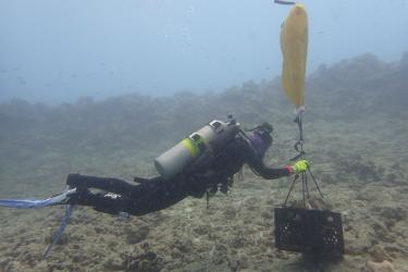
Research Methods
As the threats to coral reefs and marine ecosystems grow, our researchers lean more heavily on digital imaging to increase our monitoring capabilities.

Combining seafloor images to create 3D models of large areas of reef tract is a process called "structure-from-motion" photogrammetry, which is a new effort for our program. During this mission, we will conduct structure-from-motion surveys across the archipelago to measure the density, surface area, partial mortality, and health of corals. Our team will conduct structure-from-motion surveys at fixed stations to assess the growth, mortality, and recruitment of individual coral colonies, which will provide valuable information on the resilience of coral reefs to local and global threats.

Scientists aboard the Sette and Rainier will measure water temperature, salinity, carbonate chemistry, and other physical characteristics of the coral reef environment with an assortment of oceanographic monitoring instruments. Researchers will assess the potential early effects of ocean acidification on coral reef growth with calcification accretion units and bioerosion monitoring units.
About Us
NOAA’s Pacific Reef Assessment and Monitoring Program investigates coral reef resources across the U.S. Pacific Islands, including the Hawaiian Islands. Our work complements long-term coral reef monitoring efforts of local agencies. Partners in this mission include scientists from the State of Hawaiʻi Division of Aquatic Resources, The Nature Conservancy, and the University of Hawaiʻi.