Refine Results
Region
Management Areas
Map Type
Map Category
Topic
Species Category

Maps

457 resources match your filter criteria.

Clam Dredge Exemption Areas in the Great South Channel Habitat Management Area

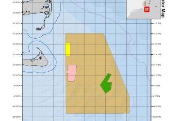
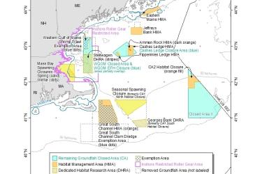
This dataset depicts the boundaries of Clam Dredge Exemption Areas in the Great South Channel Habitat Management Area under the Habitat Clam Dredge Exemption Framework.
June 04, 2020 - Map ,
Clam_Dredge_Areas_202064.jpg

Storymap: Scallop Map 2018

Take a tour of each section of the scallop regulations in 2018 in this storymap.
May 20, 2020 - Map ,
ScallopStorymap1.PNG

Georges Bank/Southern New England Scallop Dredge Exemption Area

This dataset depicts the boundaries of the Georges Bank/Southern New England (GB/SNE) Scallop Dredge Exemption Area.
May 13, 2020 - Map ,
GOM_and SG_SNE_Dredge_Exemption_Areas_202058.jpg

Gulf of Maine Scallop Dredge Exemption Area

This dataset depicts the boundaries of the Gulf of Maine (GOM) Scallop Dredge Exemption Area.
May 13, 2020 - Map ,

Redfish Exemption Area

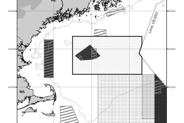
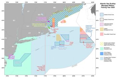
This dataset depicts the boundaries of the Redfish Exemption Area of the Sector Exemption Management Areas in ESRI shapefile format for the NOAA Fisheries Service’s Greater Atlantic Regional Fisheries Office (GARFO).
April 28, 2020 - Map ,
RedfishExemption_MAP_202051.jpg

Stellwagen Bank National Marine Sanctuary Shipwreck Sites

This dataset depicts the location of known shipwrecks on Stellwagen Bank.
April 15, 2020 - Map ,

Atlantic Sea Scallop Managed Waters Fishing Year 2021

This dataset depicts the boundaries of Atlantic Sea Scallop Managed Waters for Fishing Year 2021 under Framework 33.
April 10, 2020 - Map ,
Scallop_Wall_Map_Color_2020615.jpg

Essential Fish Habitat - Groundfish and Salmon

Maps and GIS data
February 06, 2020 - Map ,

Omnibus Essential Fish Habitat Amendment 2 Map

OHA2 was initiated in 2004 to review and update the EFH components of all the New England Fishery Management Council's fishery management plans (FMP).
November 01, 2019 - Map ,
Final_Approved_Measures_20180405_low_res.jpg

West of Cutler Set-Aside Area

This dataset depicts the boundaries of the West of Cutler Set-Aside Area.
October 14, 2019 - Map ,