Refine Results
Region
Management Areas
Map Type
Map Category
Topic
Species Category

Maps

6 resources match your filter criteria.

Species and Habitat App

Web mapping app that displays and queries spatial data in the West Coast Region for Endangered Species Act ranges, critical habitat designations, and Magnuson-Stevens Act essential fish habitat. Users can generate a printable spatial query report.
April 28, 2024 - Map ,

Steller Sea Lion Western DPS Critical Habitat Map and GIS data

Map and GIS data representing critical habitat for the Western distinct population segment (DPS) of Steller Sea Lion
April 14, 2022 - Map ,

Critical Habitat - Maps and GIS Data (West Coast Region)

Maps and GIS data for black abalone, bocaccio, Chinook salmon, chum salmon, coho salmon, eulachon, green sturgeon, humpback whale, killer whale, leatherback turtle, sockeye salmon, steelhead trout, Steller sea lion, and yelloweye rockfish.
December 03, 2021 - Map ,

Humpback Whale Critical Habitat Maps and GIS Data

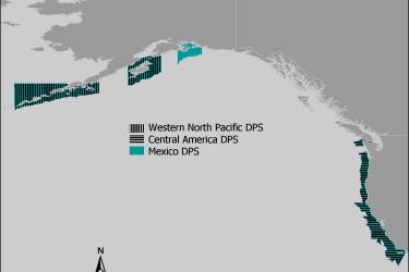
Maps and GIS data representing critical habitat for the Western North Pacific distinct population segment (DPS), the Central America DPS, and the Mexico DPS of humpback whales.
April 21, 2021 - Map ,
Humpback Whale Critical Habitat

Salmon Habitat Status and Trend Monitoring Program Data

Habitat data sets for habitat status and trend monitoring in Puget Sound and the Oregon Coast Coho regions.
June 18, 2020 - Map ,

Leatherback Turtle Critical Habitat Map and GIS Data

Map and GIS data representing critical habitat for the conservation of endangered leatherback turtles.
June 26, 2019 - Map ,
map-leatherback-turtle-critical-habitat-Caribbean-SERO.jpg