Refine Results
Region
Management Areas
Map Type
Map Category
Topic
Species Category

Maps

172 resources match your filter criteria.

New and Existing Restricted Areas: 2021 Atlantic Large Whale Take Reduction Plan Modifications

Two new restricted areas were added in the 2021 amendments to the Atlantic Large Whale Take Reduction Plan, and two others were modified.
October 05, 2021 - Map ,
New and old restricted areas for lobster and Jonah crab trap pot fishermen

Social Indicators of Gentrification Pressure

How Gentrification is Affecting 29 Fishing Communities in the Northeast United States
May 26, 2021 - Map ,
Surf crashing on rocks.

Omnibus Deep-Sea Coral Amendment

Maps and GIS data representing Omnibus Deep-Sea Coral Amendment.
April 17, 2021 - Map ,

Herring Inshore Midwater Trawl Restricted Area

This dataset depicts the boundaries of the Inshore Midwater Trawl Restricted Area in ESRI shapefile format as described in Amendment 8 of the Atlantic Herring Fishery Management Plan.
February 16, 2021 - Map ,
Inshore Midwater Trawl Restricted Area Map

Cashes Ledge Groundfish Closure Area

Cashes Ledge Groundfish Closure Area is included in the Northeast Multispecies Closed Area Regulations for the Gulf of Maine.
October 01, 2020 - Map ,
Cashes Ledge Groundfish Closure Area. This map includes the Ammen Rock Area Habitat Management Area, Fippennies Ledge Habitat Management Area and the Cashes Ledge Closure Area and Cashes Ledge Habitat Management Area. Map created 7/23/2020.

Atlantic Chub Mackerel Management Unit

This dataset depicts the boundaries of the Atlantic Chub Mackerel Management Unit under a final Rule Implementing Amendment 21 to the Atlantic Mackerel, Squid, and Butterfish Fishery Management Plan.
August 04, 2020 - Map ,
Atlantic_Chub_map_2020622.jpg

StoryMap: Oyster Reef Restoration in the Chesapeake Bay

Take a virtual tour to learn about how—and why—NOAA and partners are restoring oyster reef habitat in the Chesapeake Bay.
July 28, 2020 - Map ,
healthy Harris oysters.jpg

Clam Dredge Exemption Areas in the Great South Channel Habitat Management Area

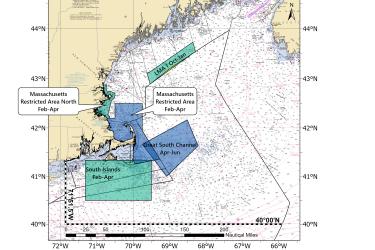
This dataset depicts the boundaries of Clam Dredge Exemption Areas in the Great South Channel Habitat Management Area under the Habitat Clam Dredge Exemption Framework.
June 04, 2020 - Map ,
Clam_Dredge_Areas_202064.jpg

Storymap: Port Agents

Take a tour of the NOAA Fisheries Port Agents in the Greater Atlantic Region.
May 22, 2020 - Map ,