What is a Drifting Acoustic Spar Buoy Recorder?

Schematic of the DASBR equipment setup. Credit: NOAA Fisheries
These recorders allow us to acoustically survey the main Hawaiian Islands on a finer scale than we can with the ship’s towed array system. They are free-floating acoustic recorders that we deploy from the ship at various locations chosen based on the ocean currents. They consist of floats, line, two hydrophones, and a Soundtrap (OceanInstrumentsNZ) data logger with anchors that reach down to a depth of 150 meters (almost 500 feet). They also provide a quieter recording platform than the ship’s towed array system. When towing hydrophones behind a ship, noise from the ship itself and water flow mask sounds from some cetaceans (whales and dolphins). Because these recorders are free floating, they do not have the same noise issue as the towed array. This means we can listen to baleen whales, in addition to the toothed whales we can detect on the towed array system. We deploy each recorder for approximately 1 month at a time, but they have to be retrieved to access the data.
How do you find something you left behind in the ocean?
With satellite transmitters! Each float attached to the acoustic recorders contains a small Iridium transmitter. At a pre-programmed time (usually every 2 hours), the transmitter looks at the satellites to determine its GPS position. It then transmits this information to the Iridium satellite network, which then sends us an email with the location. We then combine each of these locations into a track for each recorder. This system allows us to pick up the recorders when they are full of data, as well as know where they were throughout their journey. The recorder tracks can also give us a pretty good idea of what the ocean currents around Hawaiʻi look like! This whole process is not always as simple as it sounds, and electronics can be a bit finicky when you toss them into salt water. A few recorders stopped transmitting and went missing, and a few have managed to strand themselves in shallow water and required rescue. Overall, most recorders successfully completed their mission and will provide us with valuable acoustic data!

A map showing the tracks of the DASBRs we deployed during HICEAS 2017. The tracks shown in gray stopped transmitting prematurely, so we could not retrieve them. The white line shows the Hawaiian EEZ boundary (the HICEAS study area), and the gray shading is a focus area around the main Hawaiian Islands. Credit: NOAA Fisheries
What can we learn from these recorders?
Combining the location information with the acoustic recordings, we can learn quite a lot about cetaceans around the Hawaiian Islands. Drifting Acoustic Spar Buoy Recorders allow us to detect species that tend to shy away from ships or that would be quiet when other sounds in their environment are noisy. The most basic information we are gathering is the where and when a species was present around the islands. In addition, variations in calling behavior throughout the day can give us insights into the feeding patterns of detected species. By combining the information from the two hydrophones, we can learn about the dive depths of certain species, such as beaked whales. The ultimate goal is to use the data from the recorders to estimate the size of some populations, starting with beaked whales. This step is important to help us better understand and protect cetacean populations in Hawaiian waters.

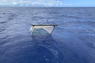
Once we deploy a DASBR, the only part visible is the buoy with the Iridium transmitter inside, and the orange float used as a marker and aid to recovery. Credit: NOAA Fisheries/Greg Sanders
Drift on over to our story map for more updates!