Refine Results
Topic
Species Category
Region

Data & Maps Results

2492 results match your filter criteria.

Christina Conrath Seminar Flyer

A flyer for presentation by Christina Conrath during the 2024 Alaska Fisheries Science Center Seminar Series.
April 02, 2024 -

Witch Flounder: QA/QC Exercise Results

Results of the QA/QC exercises for ageing witch flounder.

Atlantic Cod: QA/QC Exercise Results

Results of the QA/QC exercised for ageing Atlantic cod.

Groundfish Exclusion Areas

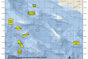
Groundfish Exclusion Areas (GEAs) are eight areas south of Point Conception, California intended to protect sensitive areas. These areas were reviewed and adopted by the Pacific Fishery Management Council in March 2023 under Alternative 3.
April 01, 2024 - Map ,
Map of Groundfish Exclusion Areas, California

Publications by Northeast Passive Acoustics Branch Staff

We regularly publish their findings in scientific journals and Center-produced documents.
April 01, 2024 - Peer-Reviewed Research ,

Atlantic Herring: QA/QC Exercise Results

Results of the QA/QC exercises for ageing Atlantic herring.

Atlantic Sea Scallop Managed Waters Fishing Year 2024

This dataset depicts the boundaries of Sea Scallop Rotational Areas for 2024.
March 28, 2024 - Map ,
Scallop Map

Derek Chamberlin Seminar Flyer

A flyer for presentation by Derek Chamberlin during the 2024 Alaska Fisheries Science Center Seminar Series.
March 25, 2024 -

Melanie Esch Seminar Flyer

A flyer for presentation by Melanie Esch during the 2024 Alaska Fisheries Science Center Seminar Series.
March 14, 2024 -

Life on an Active Volcano: Fur Seals Adapt to a Changing Landscape on Bogoslof Island - Part 2

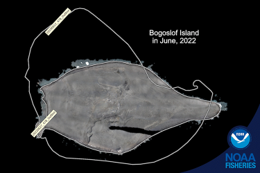
Volcanic eruptions at Bogoslof have changed the landscape dramatically. It’s home to a thriving breeding ground of northern fur seals. Scientists monitor the fur seal population every 4 years to understand how they respond to such a dynamic environment.
March 13, 2024 - Feature Story ,
Aerial view of Bogoslof Island in June 2022 showing the impact of the volcanic eruption from 2019 Aerial survey imagery from June 2022 along with a white outline showing the former size in 2019. Erosion has changed the island dramatically since it tripled in size after the eruptions in 2016-2017. Credit: NOAA Fisheries/Alexey Altukhov and Burlyn Birkemeier.