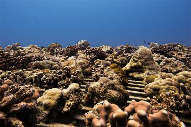
- The Office of National Marine Sanctuaries (ONMS) published a new Condition Report for Olympic Coast National Marine Sanctuary in March 2022. This report summarizes how the ecosystem is doing and describes the services that the ecosystem provided to people between 2008-2019.
- Sanctuary scientists used NOAA’s Integrated Ecosystem Assessment approach (IEA) to help update the report. This approach helps scientists prioritize key indicators that assess the status and trends of different parts of the ecosystem (e.g., water quality, physical drivers, and ecosystem services)
- National marine sanctuaries are designated protected waters, ranging from small isolated habitats to expansive ecosystems, and comprise a total of over 600,000 square miles of marine and Great Lakes waters.
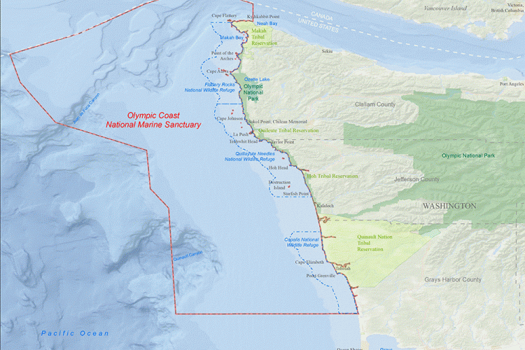
- Olympic Coast National Marine Sanctuary is located within the ‘Usual and Accustomed Fishing Areas’ of four Coastal Treaty Tribes who have lived along this coastline since time immemorial. Treaties from the 1850’s signed by the Hoh, Makah, and Quileute Tribes and the Quinault Indian Nation specifically reserved rights to marine resources in the region, and tribes continue to serve as co-managers of fishery resources.
The report highlights the relationship between humans and the ocean. It includes indigenous voices, traditional knowledge, and additional collaboration between:
- Coastal Treaty Tribes
- Fishermen
- West Coast states
- Pacific Fishery Management Council
- and NOAA Fisheries
Gathering ecosystem data is an important step to understanding the ecosystem and building a condition report. Much of the data in the report is a result of collaboration with various sources including NOAA’s IEA program. The IEA program provided data that span the entire West Coast and also narrowed down data sets to fit Olympic Coast boundaries to help this assessment. The sanctuary used data from from NOAA Fisheries' coastwide resource assessment surveys and remote observation tools. IEA scientists also assisted in identifying indicators for assessing conditions in each of the sanctuary’s six major habitats, which improved the suite indicators used in the previous condition report.
The National Center for Coastal Ocean Science (NCCOS) also supported large parts of the report process. NCCOS led indicator development, including customizing habitat conceptual models and compiling initial data sources for the report.
Explore the data in this interactive tool.
This collaboration between IEA scientists, NCCOS, and sanctuary staff to update the sanctuary condition report strengthens data sharing and usage. It also supports diverse expertise and input in building a scientifically rigorous report.
Integrated Ecosystem Approach Supports Sanctuaries
NOAA’s IEA approach helps sanctuaries improve condition reports, management plans, ongoing research, outreach, and data and information availability. A goal of NOAA’s IEA program is to help NOAA scientists and offices tackle ecosystem-based management. This approach engages stakeholders to scientists and managers. They work together to find the best understanding of key aspects of the ecosystem and carry out ecosystem-based management. The IEA process helps increase transparency and consistency of ecosystem evaluations. It helps to establish baseline standards and considerations for indicator inclusion or exclusion, and minimizes biases in reports and assessments.
Sanctuaries has used the IEA approach before, during the indicator development phase and while identifying appropriate environmental data sources at other sanctuaries including Monterey Bay, Channel Islands, and Florida Keys. In the future, IEA program staff hope to further collaborate with sanctuary sites by contributing to risk assessments, evaluating and comparing management strategies, and supporting the development of interactive infographics and conceptual models.
The effort into this condition report will also help inform the upcoming update to the Olympic Coast management plan.