Refine Results
Region
Topic
Species Category

All Science & Data

31 resources match your filter criteria.

Punahele: A Green Sea Turtle's Journey to "Destination Unknown"

Researchers perform an ultrasound and place a satellite tag on a fertile sea turtle to track her migration in the vast Pacific Ocean.
May 08, 2020 - Research ,
4032x3024_Punahale_sat_tag_CamrynAllen.JPG

Persistent Organic Pollutants in Green Sea Turtles (Chelonia Mydas) Inhabiting Two Urbanized Southern California Habitats

We asses the persistent organic pollutants in green turtle populations in the Seal Beach National Wildlife Refuge and San Diego Bay to understand the contamination risks for these populations.
April 01, 2020 - Peer-Reviewed Research ,

Recovery Action Database

Tracks the implementation of recovery actions from Endangered Species Act (ESA) recovery plans.
February 10, 2020 - Database ,
RAD image.JPG

Baseline Health Parameters of East Pacific Green Turtles at Southern California Foraging Grounds

Urban coastal ecosystems are unique intersections of human development and biodiversity, and monitoring populations in these areas is critical to understanding ecosystem health and function.
December 06, 2019 - Peer-Reviewed Research ,

Virginia Pound Net Regulated Area Map & GIS Data

Map depicting where pound net regulations are in place in Virginia state waters.
August 28, 2019 - Map ,

Large Mesh Gillnet Restricted Area Map & GIS Data

Map of large mesh gillnet regulations enacted to protect sea turtles
August 27, 2019 - Map ,

Atlantic Sea Scallop Turtle Deflector Dredge Regulated Areas Map & GIS Data

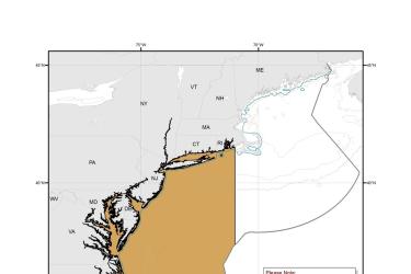
Map depicting where Turtle Deflector Dredges must be used when fishing for scallops in waters west of 71° W. long., from the shoreline to the outer boundary of the Exclusive Economic Zone, from May 1 through November 30.
August 27, 2019 - Map ,

Chain Mat-Modified Scallop Dredge Area Map & GIS Data

Map depicting where chain mats must be used when fishing for scallops in waters west of 71° W. long., from the shoreline to the outer boundary of the Exclusive Economic Zone, from May 1 through November 30.
August 27, 2019 - Map ,
Chain_Mat-Modified_Scallop_Dredge_Area_MAP.jpg

Green Turtle Critical Habitat Map and GIS Data

Map and GIS data representing critical habitat for the conservation of the threatened green turtle in the U.S. Caribbean.
June 26, 2019 - Map ,
map-green-turtle-critical-habitat-Caribbean-SERO.jpg

Field Notes: Partnering to Protect Monk Seals and Sea Turtles in the Northwestern Hawaiian Islands

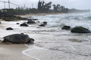
The NOAA Ship Oscar Elton Sette is departing on May 15th for a 27-day research expedition throughout the Hawaiian Islands to support research and recovery of the endangered Hawaiian monk seal and threatened green sea turtle. We will follow their progress and provide updates in these notes from the field.
May 15, 2019 - Research ,
1598897878.jpg