Refine Results
Region
Topic
Species Category

All Science & Data

15 resources match your filter criteria.

Large Mesh Gillnet Restricted Area Map & GIS Data

Map of large mesh gillnet regulations enacted to protect sea turtles
August 27, 2019 - Map ,

Atlantic Sea Scallop Turtle Deflector Dredge Regulated Areas Map & GIS Data

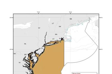
Map depicting where Turtle Deflector Dredges must be used when fishing for scallops in waters west of 71° W. long., from the shoreline to the outer boundary of the Exclusive Economic Zone, from May 1 through November 30.
August 27, 2019 - Map ,

Chain Mat-Modified Scallop Dredge Area Map & GIS Data

Map depicting where chain mats must be used when fishing for scallops in waters west of 71° W. long., from the shoreline to the outer boundary of the Exclusive Economic Zone, from May 1 through November 30.
August 27, 2019 - Map ,
Chain_Mat-Modified_Scallop_Dredge_Area_MAP.jpg

Leatherback Turtle Critical Habitat Map and GIS Data

Map and GIS data representing critical habitat for the conservation of endangered leatherback turtles.
June 26, 2019 - Map ,
map-leatherback-turtle-critical-habitat-Caribbean-SERO.jpg

Alaska Endangered Species and Critical Habitat Mapper Web Application

Spacial data and maps of critical habitat and Endangered Species Act (ESA) threatened and endangered marine mammals under NOAA Fisheries jurisdiction in Alaska.
January 29, 2018 - Query Tool ,