Map containing ocean temperatures recorded during Alaska Fisheries Science Center Bottom Trawl surveys of the surrounding waters of the Aleutian Islands.
Map containing ocean temperatures recorded during Alaska Fisheries Science Center Bottom Trawl surveys of the eastern Bering Sea and northern Bering Sea.
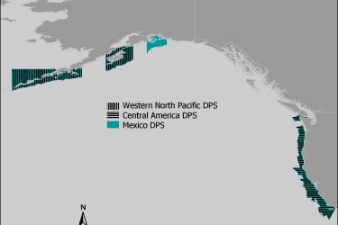
Maps and GIS data representing critical habitat for the Western North Pacific distinct population segment (DPS), the Central America DPS, and the Mexico DPS of humpback whales.