Refine Results
Region
Management Areas
Map Type
Map Category
Topic
Species Category

Maps

172 resources match your filter criteria.

Northeast Canyons and Seamounts Marine National Monument Map & GIS Data

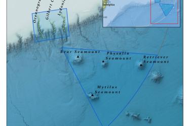
The Northeast Canyons and Seamounts National Monument consists of approximately 4,913 square miles (12,724 square kilometers) and is located about 130 miles east-southeast of Cape Cod.
August 30, 2019 - Map ,
Northeast_Canyons_and_Seamounts_Marine_National_Monument_MAP.jpg

Lobster Restricted Gear Areas

Map and GIS data representing four restricted gear areas.
August 28, 2019 - Map ,

Lobster Management Areas

Map and GIS data representing seven Lobster Management Areas.
August 28, 2019 - Map ,

Lobster Gear Areas

Map and GIS data representing four gear areas for the American lobster fishery.
August 28, 2019 - Map ,

Exempted Waters for Maine State Lobster Permits

Map and GIS data representing the exempted waters for Maine State American lobster permits, also known as "Maine Pocket Waters."
August 28, 2019 - Map ,

Virginia Pound Net Regulated Area Map & GIS Data

Map depicting where pound net regulations are in place in Virginia state waters.
August 28, 2019 - Map ,

Large Mesh Gillnet Restricted Area Map & GIS Data

Map of large mesh gillnet regulations enacted to protect sea turtles
August 27, 2019 - Map ,

Atlantic Sea Scallop Turtle Deflector Dredge Regulated Areas Map & GIS Data

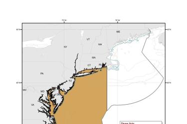
Map depicting where Turtle Deflector Dredges must be used when fishing for scallops in waters west of 71° W. long., from the shoreline to the outer boundary of the Exclusive Economic Zone, from May 1 through November 30.
August 27, 2019 - Map ,

Chain Mat-Modified Scallop Dredge Area Map & GIS Data

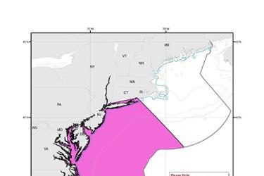
Map depicting where chain mats must be used when fishing for scallops in waters west of 71° W. long., from the shoreline to the outer boundary of the Exclusive Economic Zone, from May 1 through November 30.
August 27, 2019 - Map ,
Chain_Mat-Modified_Scallop_Dredge_Area_MAP.jpg

Forage Species Management Unit

Map and GIS data representing the area where catches of 17 forage species must be reported.
August 27, 2019 - Map ,
500_Mid-Atlantic_Forage_Species_Management_Unit_MAP.jpg