Refine Results
Region
Management Areas
Map Type
Map Category
Topic
Species Category

Maps

17 resources match your filter criteria.

Species and Habitat App

Web mapping app that displays and queries spatial data in the West Coast Region for Endangered Species Act ranges, critical habitat designations, and Magnuson-Stevens Act essential fish habitat. Users can generate a printable spatial query report.
April 28, 2024 - Map ,

Groundfish Exclusion Areas

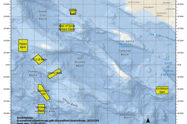
Groundfish Exclusion Areas (GEAs) are eight areas south of Point Conception, California intended to protect sensitive areas. These areas were reviewed and adopted by the Pacific Fishery Management Council in March 2023 under Alternative 3.
April 01, 2024 - Map ,
Map of Groundfish Exclusion Areas, California

Florence Yelloweye Rockfish Conservation Area

This dataset depicts the boundaries of the Florence Yelloweye Rockfish Conservation Area (YRCA) off central Oregon.
March 07, 2024 - Map ,

Heceta Bank Yelloweye Rockfish Conservation Area

This dataset depicts the boundaries of the Heceta Bank Yelloweye Rockfish Conservation Area (YRCA) off central Oregon.
March 07, 2024 - Map ,
Map of Heceta Bank Yelloweye Rockfish Conservation Area

Newport Yelloweye Rockfish Conservation Area

This dataset depicts the boundaries of the Newport Yelloweye Rockfish Conservation Area (YRCA) off central Oregon.
March 07, 2024 - Map ,
Map of the Newport Yelloweye Rockfish Conservation Area

Tillamook Yelloweye Rockfish Conservation Area

This dataset depicts the boundaries of the Tillamook Yelloweye Rockfish Conservation Area (YRCA) off northern Oregon.
March 07, 2024 - Map ,
Map showing Tillamook Yelloweye Rockfish Conservation Area

Sunflower Sea Star Fact Sheets

Sunflower sea stars are native to marine waters along the Pacific Coast, from northern Baja California to the central Aleutian Islands.
March 14, 2023 - Map ,

Harbor Seals Pupping Timeframes Along the West Coast

Maps for California, Oregon, Washington and the Pacific Coast
April 20, 2022 - Map ,
Map of the West Coast showing habor seal pupping areas for February - April, March - May, March - June, mid-April - July, May - July, June - August, late-June - September, August - October

Steller Sea Lion Western DPS Critical Habitat Map and GIS data

Map and GIS data representing critical habitat for the Western distinct population segment (DPS) of Steller Sea Lion
April 14, 2022 - Map ,