Post 1 Chief Scientist’s Weather Report: rain and drizzle, followed by a big sigh of relief as the ship finally pulled away from port.
A team of scientists from the United States and Canada aboard NOAA Ship Henry B. Bigelow left the Newport Naval Base in Rhode Island on June 14 to spend 14 days at sea exploring deepwater habitats and searching for deep-sea corals. Our focus: the submarine canyons and continental slope off the Northeast U.S. and Atlantic Canada, as well as deep habitats within the relatively shallow Gulf of Maine.

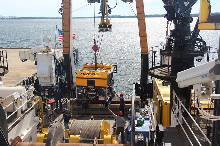
Led by Martha Nizinski from the NOAA Fisheries National Systematics Lab and Anna Metaxas from Dalhousie University in Nova Scotia, the team is using the Canadian remotely operated vehicle (ROV) Remotely Operated Platform for Ocean Science (ROPOS). We intend to survey a minor submarine canyon between Powell and Munson canyons (United States), two minor canyons near Kinlan Canyon (United States), Corsair Canyon (Canada), Northeast Channel Coral Conservation Area (Canada), and Outer Schoodic Ridge and western Jordan Basin in the northern Gulf of Maine (United States).
Two previous ROPOS transboundary explorations were conducted on the Bigelow in 2014 and 2017.

For this current expedition, our overall goals and objectives are the same and are a continuation of the earlier surveys. These include:
- Surveying canyon, slope, and basin areas, with concurrent sampling of environmental factors (i.e., depth, salinity, temperature, dissolved oxygen) in order to characterize benthic (bottom) habitats and identify areas of deep-sea coral presence;
- Ground-truthing and validating models that we use to predict deep-sea coral presence;
- Assessing deep-sea coral abundance, distribution, and size;
- Classifying deep-sea coral and adjacent soft sediment habitats and document species associations;
- Collecting deep-sea corals for taxonomic, reproduction, and age analyses;
- Collecting deep-sea corals and other invertebrates for genetic studies;
- Conducting seafloor mapping in areas where data are missing or incomplete;
- Evaluating placement of boundaries around areas designated as marine management areas.
Using ROPOS as the primary sampling gear, the team will spend approximately two days in each canyon, with the remaining time split between several locations in the northern Gulf of Maine. During each 12-hour deployment, ROPOS will take high-definition video and still images of the seafloor and collect deep-sea coral samples, other invertebrates, and sediment cores.

When ROPOS is on board the ship, the team will conduct a variety of other ship-based operations to study these canyon and deep-sea coral habitats in more detail. The ship’s seafloor mapping system will map regions where data are missing or incomplete. By filling in these “blanks,” the team aims to have a complete high-quality image of the seafloor and its topography. These maps will be important for mission planning, not only for this cruise, but also for future missions in the region.
Additionally, a CTD (for conductivity, temperature, and depth) will be deployed to aid in the characterization of the water column. This instrument records the depth, salinity, and temperature profile of the water column. Water column samples will be collected from the CTD for nutrient analyses and isotopic signatures.
Please check back with us to learn more about our cruise and what we have discovered!
Martha Nizinski, NOAA Fisheries Office of Science & Technology, National Systematics Laboratory
Dave Packer, NOAA Fisheries Northeast Fisheries Science Center
Aboard the NOAA Ship Henry B. Bigelow


