On March 21, 2021, 89 North Atlantic right whales were spotted by scientists from the Center for Coastal Studies in Cape Cod Bay. Just a few days later, on March 30, scientists spotted 57 North Atlantic right whales off Southeast New England in and around the wind energy development areas. They were seen by scientists from the Northeast Fisheries Science Center flying a sighting survey. Three mother/calf pairs have been sighted there to date.
Right whales have typically appeared in Cape Cod Bay during spring, but in recent years have been arriving sooner and staying longer. Right whale use of areas south and west of Nantucket Shoals has been documented in just the last 10 years. In recent years, the right whales appear to be staying in these waters in greater numbers and for longer periods than in the past.
What gives? To find out, we track when and where these whales are found throughout the year, using sighting surveys and passive acoustic listening devices.
“A very small portion of the right whale population heads south to the waters off northern Florida and Georgia in the winter—mostly just the moms—to give birth,“ said Tim Cole, a marine mammal researcher and lead of the center’s aerial whale survey team. We try to determine where the rest of the population is and have found them so far this year in large numbers on Nantucket Shoals south of Martha’s Vineyard and Nantucket, and in Cape Cod Bay.”

Northeast Fisheries Science Center, New England Aquarium, the Center for Coastal Studies, and others jointly monitor the waters off New England for right whales. The whales tend to follow their food and are moving to different foraging locations around the region as the season progresses.
There are a number of seasonal and year-round rules in place to protect these endangered animals. The rules address the top two threats to their recovery: entanglement in fishing gear and collisions with vessels. In 2017, a spate of right whale deaths occurred in the United States and Canada. Evidence pointed to vessel strikes and entanglement as the primary causes. This triggered the declaration of an unusual mortality event, which is ongoing.
This declaration allows the agency to more easily focus resources on preventing more serious injuries or deaths. It also helps us to understand potential causes, the effect on the population as a whole, and the role of environmental factors in the event. To date, 49 known cases (34 dead and 15 seriously injured whales) have been documented as part of the unusual mortality event. This represents more than 10 percent of the population and a significant setback to the species’ recovery.
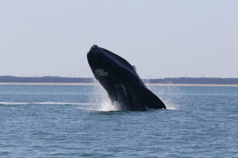
Following Their Food
Surveys in Cape Cod Bay are finding large numbers of whales as spring arrives in the bay along with food the whales need. On March 16, 78 right whales were sighted by the Center for Coastal Studies aerial survey team. On March 21, the 89 whales sighted included three pairs of mothers and calves.
In addition to aerial surveys, center scientist Lisa Conger and her colleagues are on the water, working under COVID-19 safety protocols. They are photographing right whales in Cape Cod Bay aboard the center’s research vessel Selkie. On March 22, their first day on the water, the scientists sighted their first right whale mother-and-calf pair of the season in the bay. The mother, known as Bocce, and her calf were photographed in a group of whales active at the water’s surface.

The researchers are focused on taking photographs to use in identifying individual whales. They are also collecting small skin samples from whales not already sampled. The samples are used for population genetic studies. Bocce’s calf had already been skin-sampled in the calving grounds in the southeast this winter by colleagues there. The center’s four-person at-sea team, which often includes a colleague from the New England Aquarium’s right whale team, will continue these efforts until early May, when most of the whales are expected to leave the bay for other areas.
Aerial Surveys Planned Into the Fall
“The Northeast Shelf and particularly the Gulf of Maine and areas south of Cape Cod are huge areas to cover, so you can easily miss whales during these surveys,” Cole said. “We have intensified our efforts to observe and identify as many right whales as we can to determine the status of the population and assist in monitoring the health of individual animals.”

Weather permitting, Cole and center colleagues conduct aerial surveys several times a week. They’re specifically looking for right whales, but note all large whales. Flights are focused on areas where whales have been seen recently or in the past.
“We photograph each animal and then analyze the images to get a record of the numbers of individual animals here, how long they stay here, and what the population looks like in terms of males, females, and calves so we can follow the family tree, so to speak,” Cole said. “This year, 17 live calves were observed in the coastal waters off of the Southeast United States. To date, survey teams in the region have sighted at least nine of these mother and calf pairs this spring in the Northeast.”
Vessel Surveys Complement Aerial Efforts
Cole and his colleagues will be flying through June 15, when the NOAA Twin Otter aircraft will be assigned to another center survey project through September. “Hopefully the Center for Coastal Studies and New England Aquarium will be able to fill in for us until we get the plane back in October,” Cole said.
Center researchers will be conducting aerial and shipboard surveys through the summer in waters from Halifax, Nova Scotia to North Carolina. The effort is part of the long-running Atlantic Marine Assessment Program for Protected Species. It is funded by NOAA, the Bureau of Ocean Energy Management, and the U.S. Navy. Our center will survey Northeast waters, and NOAA’s Southeast Fisheries Science Center will conduct similar surveys in Southeast waters. Together, we’re providing aerial and ship-based coverage off the entire East Coast.
“The goal of these surveys is to update many different marine species abundance estimates and the Atlantic marine mammal stock assessment reports,” said Debra Palka, a research fishery biologist who coordinates the program for the East Coast. “It will also be used to see how these populations may be changing over time, and help assess the effects of human interactions—bycatch from fishing operations, wind farms, U.S. Navy activities and the like—on protected marine species.
Recreational Fishermen, Vessel Operators Can Help Protect Whales
NOAA Fisheries and other partners are also focusing outreach efforts on recreational fishermen who are getting on the water as the weather warms. We’re reminding them to slow down and stay clear of the whales.
The way to do that is by using FishRules, an app that provides quick access to state and federal recreational fishing regulations. It has added information on North Atlantic right whale approach prohibitions and how to report distressed whales.
NOAA Fisheries’ Slow Zones program designates 10-knot speed zones when groups of whales are detected in waters from Maine through Virginia. Operators of all vessels are asked to slow down to 10 knots or less for 15 days after a sighting in those areas.
The interactive right whale sightings map displays locations where right whales have been reported. Mariners are asked to stay aware of mandatory and voluntarily vessel speed restriction areas to avoid striking right whales.