There is light at the end of the tunnel as many of the restrictions associated with the coronavirus pandemic start to relax. However, restarting large-scale research and survey operations takes time. The 2020 Pacific Islands Fisheries Science Center Bottomfish Fishery-Independent Survey in Hawaiʻi (#BFISH) was highly successful. It showed that cooperative research fishers, working in partnership with NOAA, can achieve a high degree of effectiveness and efficiency. In 2021, NOAA will continue to rely on our 10-year cooperative research partnership with the local fishing community to conduct survey operations critical to fishery management in Hawaiʻi.
The annual survey became operational in 2016. It continues to provide important local abundance estimates used in the Main Hawaiian Islands Deep 7 Bottomfish Stock Assessment.

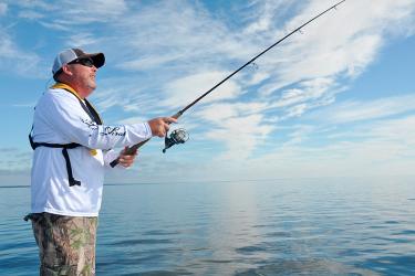
A key difference between #BFISH and many of our other research missions is its foundational partnership with the local fishing community. Traditionally, the NOAA Ship Oscar Elton Sette conducts stereo-video camera deployments. Local fishers contracted through Lynker Technologies and the Pacific Islands Fisheries Group conduct research fishing operations. They use traditional hook-and-line methods to collect samples within an experimental design developed in close partnership with Pacific Islands Fisheries Science Center scientists. As in 2020, our Lynker/Pacific Islands Fisheries Group partners will conduct 100 percent of the sampling, including both fishing and camera operations.

This year, Lynker/Pacfic Islands Fisheries Group camera operations will expand from Oʻahu to all islands except Niʻihau and Kauaʻi. Also this year, each of the fishing lines will be outfitted with the same temperature/depth recorders that are used on the camera systems. This will allow NOAA researchers to get a better idea of depth and sea water temperature at the exact time and location they caught each fish. This data will help to provide information on how the Deep 7 stock may respond to changing environmental conditions.
The survey will also expand from 500 to 750 sampling stations. This will provide valuable additional data allowing NOAA to optimize future sampling efforts to achieve maximum efficiency.
Working Together Safely

These small, open-deck fishing vessels have small crews and typically go out for single- or multi-day operations. All parties will continue to follow precautions recommended by the Center for Disease Control to make sampling as safe as possible.
Research fishing operations began July 1 and will run through the end of November. Research fishers are conducting hook-and-line sampling at 650 locations across the main Hawaiian Islands. They will be deploying the MOUSS stereo-video camera system at 100 locations around Oʻahu, Penguin Banks, Molokaʻi, Maui, Lanaʻi, Kahoʻolawe, and Hawaiʻi Island.
Thanks to the perseverance of these local fishers, our scientists will be able to maintain a continuous data stream for the Main Hawaiian Islands Deep 7 Bottomfish Stock Assessment. This will allow managers to set sustainable commercial catch limits for the fishery.


What Happens to All the Fish?

The fishers retain all Deep 7 fish caught during research operations, and return other species to the sea. They send a portion of the retained fish to the Pacific Islands Life History Program for age, growth, maturity, and genetic studies. These are important information for stock assessments and to further our understanding of the basic biology, ecology, and production of these species. Those fish not needed for life history research are sent to Local I’a for processing (head, gut, or filet). Kokua Kalihi Valley will then distribute the fish through their Roots Project. The project provides community food boxes to Kokua Kalihi Valley's Elder Care, Diabetes and Nutrition programs, Youth Services, and Medical teams.
The annual bottomfish survey is a partnership between the following: