NATIONAL OCEANIC AND ATMOSPHERIC ADMINISTRATION
|
U.S. DEPARTMENT OF COMMERCE
Facebook
Instagram
Twitter
YouTube
Mail
|
SITE INDEX
CONTACT US
Close Promo Banner
Search NOAA Fisheries
Search
Menu
Find A Species
Find a Species
Dolphins & Porpoises
Fish & Sharks
Highly Migratory Species
Invertebrates
Sea Turtles
Seals & Sea Lions
Whales
Protected Species
All Threatened & Endangered Species
Marine Mammals
Species By Region
Alaska
New England/Mid-Atlantic
Pacific Islands
Southeast
West Coast
Helpful Resources
Marine Life Viewing Guidelines
Marine Life in Distress
Report a Stranded or Injured Marine Animal
Species in the Spotlight
Fishing & Seafood
Sustainable Fisheries
Bycatch
Catch Shares
Fishery Observers
Illegal, Unregulated, Unreported Fishing
Magnuson-Stevens Act
Research Surveys
Population Assessments
Resources for Fishing
Commercial Fishing
Recreational Fishing
Subsistence Fishing
Fishery Management Info
Permits & Forms
Rules & Regulations by Region
Sustainable Seafood
Seafood Profiles
Aquaculture
Commerce & Trade
Seafood Inspection
Related Topics
Atlantic Highly Migratory Species
Offshore Wind Energy
Cooperative Research
Enforcement
Financial Services
International Affairs
Science & Data
Socioeconomics
Protecting Marine Life
Endangered Species Conservation
Listing Species Under ESA
Critical Habitat
Consultations
Species Recovery
Research Surveys
Species in the Spotlight
Endangered Species Act
Marine Mammal Protection
Health & Stranding Response
Marine Mammal Protection Act
Research Surveys
Population Assessments
Take Reduction Plans
Marine Life in Distress
Report a Stranded or Injured Marine Animal
Bycatch
Ocean Acoustics/Noise
Unusual Mortality Events
Vessel Strikes
Related Topics
Marine Life Viewing Guidelines
Enforcement
Funding Opportunities
International Cooperation
Permits & Authorizations
Regulations & Actions
Offshore Wind Energy
Science & Data
Environment
Ecosystems
U.S. Regional Ecosystems
Management
Science
Habitat Conservation
Habitat Restoration
Habitat Protection
Types of Habitat
Habitat by Region
Science
Consultations
Climate Change
Understanding the Impacts
Climate Change Solutions
Climate, Ecosystems & Fisheries Initiative
Regional Activities
Offshore Wind Energy
Regions
Our Regions
Alaska
New England/ Mid-Atlantic
Pacific Islands
Southeast
West Coast
Contact Us
Regional Offices
Science Centers
Resources & Services
Rules & Regulations
Fisheries Rules & Regs
Fisheries Management Info
Protected Resources Regs & Actions
Permits
Fishing & Seafood
Protected Resources
International & Trade
Funding & Financial Services
Funding Opportunities
Financial Services
Prescott Grants
Saltonstall-Kennedy Grants
Habitat Restoration Grants
Consultations
Habitat
Endangered Species
Tribal
Science & Data
Research
Surveys
Data
Maps & GIS
Publications
Published Research
Key Reports
Documents
Publication Databases
Outreach Materials
Laws & Policies
Magnuson-Stevens Act
Endangered Species Act
Marine Mammal Protection Act
Policies
Outreach & Education
For Educators
For Students
Educational Materials
Outreach Materials
Teacher at Sea
Events
About Us
NOAA Fisheries
Our Mission
Who We Are
Where We Work
Our History
News & Media
News & Announcements
Bulletins
Multimedia
Science Blogs
Events
Video Gallery
Photo Gallery
Careers & More
Career Paths
Inflation Reduction Act Opportunities
Internships
Volunteering and Citizen Science
Diversity & Inclusion
Contact Us
National Program Offices
Regional Offices
Science Centers
Our Partners
Regional Fishery Management Councils
Marine Fisheries Advisory Committee
American Fisheries Advisory Committee
Government Agencies
Non-Government Organizations
Inflation Reduction Act
Priority Investments
Recent Updates
Habitat Restoration
North Atlantic Right Whales
Pacific Salmon
Red Snapper
Search NOAA Fisheries
Search
Find A Species
Back
Find A Species
Find a Species
Dolphins & Porpoises
Fish & Sharks
Highly Migratory Species
Invertebrates
Sea Turtles
Seals & Sea Lions
Whales
Protected Species
All Threatened & Endangered Species
Marine Mammals
Species By Region
Alaska
New England/Mid-Atlantic
Pacific Islands
Southeast
West Coast
Helpful Resources
Marine Life Viewing Guidelines
Marine Life in Distress
Report a Stranded or Injured Marine Animal
Species in the Spotlight
Fishing & Seafood
Back
Fishing & Seafood
Sustainable Fisheries
Bycatch
Catch Shares
Fishery Observers
Illegal, Unregulated, Unreported Fishing
Magnuson-Stevens Act
Research Surveys
Population Assessments
Resources for Fishing
Commercial Fishing
Recreational Fishing
Subsistence Fishing
Fishery Management Info
Permits & Forms
Rules & Regulations by Region
Sustainable Seafood
Seafood Profiles
Aquaculture
Commerce & Trade
Seafood Inspection
Related Topics
Atlantic Highly Migratory Species
Offshore Wind Energy
Cooperative Research
Enforcement
Financial Services
International Affairs
Science & Data
Socioeconomics
Protecting Marine Life
Back
Protecting Marine Life
Endangered Species Conservation
Listing Species Under ESA
Critical Habitat
Consultations
Species Recovery
Research Surveys
Species in the Spotlight
Endangered Species Act
Marine Mammal Protection
Health & Stranding Response
Marine Mammal Protection Act
Research Surveys
Population Assessments
Take Reduction Plans
Marine Life in Distress
Report a Stranded or Injured Marine Animal
Bycatch
Ocean Acoustics/Noise
Unusual Mortality Events
Vessel Strikes
Related Topics
Marine Life Viewing Guidelines
Enforcement
Funding Opportunities
International Cooperation
Permits & Authorizations
Regulations & Actions
Offshore Wind Energy
Science & Data
Environment
Back
Environment
Ecosystems
U.S. Regional Ecosystems
Management
Science
Habitat Conservation
Habitat Restoration
Habitat Protection
Types of Habitat
Habitat by Region
Science
Consultations
Climate Change
Understanding the Impacts
Climate Change Solutions
Climate, Ecosystems & Fisheries Initiative
Regional Activities
Offshore Wind Energy
Regions
Back
Regions
Our Regions
Alaska
New England/ Mid-Atlantic
Pacific Islands
Southeast
West Coast
Contact Us
Regional Offices
Science Centers
Resources & Services
Back
Resources & Services
Rules & Regulations
Fisheries Rules & Regs
Fisheries Management Info
Protected Resources Regs & Actions
Permits
Fishing & Seafood
Protected Resources
International & Trade
Funding & Financial Services
Funding Opportunities
Financial Services
Prescott Grants
Saltonstall-Kennedy Grants
Habitat Restoration Grants
Consultations
Habitat
Endangered Species
Tribal
Science & Data
Research
Surveys
Data
Maps & GIS
Publications
Published Research
Key Reports
Documents
Publication Databases
Outreach Materials
Laws & Policies
Magnuson-Stevens Act
Endangered Species Act
Marine Mammal Protection Act
Policies
Outreach & Education
For Educators
For Students
Educational Materials
Outreach Materials
Teacher at Sea
Events
About Us
Back
About Us
NOAA Fisheries
Our Mission
Who We Are
Where We Work
Our History
News & Media
News & Announcements
Bulletins
Multimedia
Science Blogs
Events
Video Gallery
Photo Gallery
Careers & More
Career Paths
Inflation Reduction Act Opportunities
Internships
Volunteering and Citizen Science
Diversity & Inclusion
Contact Us
National Program Offices
Regional Offices
Science Centers
Our Partners
Regional Fishery Management Councils
Marine Fisheries Advisory Committee
American Fisheries Advisory Committee
Government Agencies
Non-Government Organizations
Inflation Reduction Act
Priority Investments
Recent Updates
Habitat Restoration
North Atlantic Right Whales
Pacific Salmon
Red Snapper
Refine Results
Title
Topic
About Us
Aquaculture
Atlantic Highly Migratory Species
Bycatch
Careers & More
Chesapeake Bay
Climate
Commercial Fishing
Consultations
Ecosystems
Endangered Species Conservation
Enforcement
Fisheries Observers
Funding & Financial Services
Habitat Conservation
International Affairs
Laws & Policies
Marine Life in Distress
Marine Life Viewing Guidelines
Marine Mammal Protection
Offshore Wind Energy
Outreach and Education
Partners
Population Assessments
Recreational Fishing
Recreational Fishing Data
Resources for Fishing
Rules & Regulations
Science & Data
Seafood Commerce & Trade
Socioeconomics
Subsistence Fishing
Sustainable Fisheries
Sustainable Seafood
Teacher at Sea
Species Category
Dolphins & Porpoises
Fish
Invertebrates
Sea Turtles
Seals & Sea Lions
Whales
Species
Region
Alaska
New England/Mid-Atlantic
Pacific Islands
Southeast
West Coast
National
International
Foreign
Filter Results
"Marine Protected Areas"
Marine Protected Areas Results
6
results match your filter criteria.
Yelloweye Rockfish Conservation Areas
Links to data on Yelloweye Rockfish Conservation Areas
May 15, 2024
-
Map
,
West Coast
Evaluation of MPA Designs That Protect Highly Mobile Megafauna Now and Under Climate Change Scenarios
We study how large-scale marine protected area designs can be improved by taking animal time and space movement into consideration.
June 01, 2022
-
Peer-Reviewed Research
,
Pacific Islands
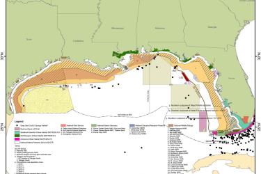
Gulf of Mexico Seasonal and/Or Area Closures and Marine Protected Areas
Map of all seasonal closures and marine protected areas (MPAs) in the Gulf of Mexico.
June 27, 2019
-
Map
,
Southeast
Gulf of Mexico Seasonal and/Or Area Closures and Marine Protected Areas
Map of all seasonal closures and marine protected areas (MPAs) in the Gulf of Mexico.
June 27, 2019
-
Map
,
Southeast
Modeling and Mapping Regional-Scale Patterns of Fishing Impact and Fish Stocks to Support Coral-Reef Management in Micronesia
Presents a baseline map of fishing impact in U.S. Territories and other Micronesian localities.
July 09, 2018
-
Peer-Reviewed Research
,
Pacific Islands
Ocean Futures Under Ocean Acidification, Marine Protection, and Changing Fishing Pressures Explored Using a Worldwide Suite of Ecosystem Models
Scientists from Norway, the United States, France, and Australia evaluated the effects of ocean acidification, marine protected areas, and fishing pressure on eight different marine ecosystems.
March 01, 2018
-
Peer-Reviewed Research
,
National