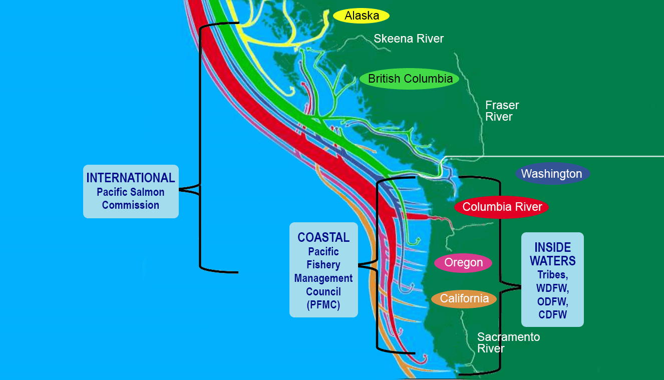
West Coast Salmon and Steelhead Fisheries Management Map
Pacific salmon and steelhead range occurs over large geographic and different environments along the West Coast which include freshwater rivers, streams, and coastal ocean waters of the United States and Canada.
Image
The map below illustrates the different organizations that work together to guide Pacific salmon and steelhead fisheries management throughout their range. Each colored line represents the migratory patterns of where Pacific salmon of a given region travel. These colored paths show where the Pacific salmon begin their life cycle, the distances salmon can travel along the West Coast as they mature, and where adult salmon may be caught. The journey salmon follow affects which management forums are involved for specific species.
- The Pacific Salmon Commission enables the implementation of principles from the Pacific Salmon Treaty among cooperative participants in the international ocean waters off Alaska, Canada, Washington, and Oregon.
- The Pacific Fishery Management Council manages the fisheries in the coastal waters of the U.S. states of Washington, Oregon, and California from 3 to 200 miles offshore.
- The management authorities of U.S. ocean waters from 0 to 3 miles offshore and inland (inside waters) fisheries are the tribes, and the Alaska, Washington, Oregon, Idaho, and California Departments of Fish and Wildlife (or Fish and Game). Inland fisheries include water-influenced environments located within land boundaries such as wetlands, estuaries, bays, and rivers.
More Information
More Information
- West Coast Salmon and Steelhead Fisheries Management
- Salmon and Steelhead Fisheries in the Mainstem Columbia River and Snake River
- Puget Sound Salmon and Steelhead Fisheries
- Pacific Fishery Management Council
- Pacific Salmon Treaty and the Pacific Salmon Commission
- Ecosystem Interactions and Pacific Salmon
- Salmon Life Cycle and Seasonal Fishery Planning
- Pacific Salmon and Steelhead Fisheries Management Glossary