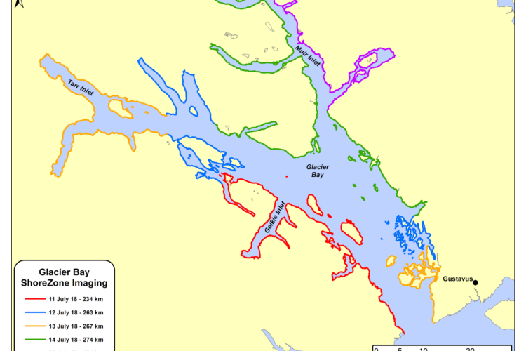
Our last day! Day five was a grey and rainy day but still produced some great imagery. You can’t fail with a park full of mountains, glaciers, inlets, deltas, and lagoons. We have covered 1,172 km capturing some truly spectacular coastal habitats (12 hrs of video and 12,614 still images).
Although Glacier Bay National Park and Preserve is known for its beauty it’s also undergoing rapid change as glaciers retreat and new coastal habitats are emerging.
This ShoreZone imaging survey has been timely and able to capture and document changes even just in the past few years. Maybe another ShoreZone survey will be needed in the not so distant future!

Aerial ShoreZone image taken July 15, 2018 of Pt. McLeod, Muir Inlet, Glacier Bay National Park & Preserve.
A textbook example of erosion and deposition. The upland watershed (fed by a high altitude glacier) is actively transporting material down the river forming an impressive delta. On the delta you can see how dynamic these processes have been: non-vegetated areas with newly deposited material and older depositional areas where willow and alder have established themselves. The offloading of excess material into the inlet can dramatically change the water quality making conditions very difficult for marine life in the immediate area. The benefits of this runoff to the greater ecosystem is that it brings vital nutrients for jumpstarting the marine food chain.

Aerial ShoreZone image taken July 15, 2018 of Adams Inlet, Glacier Bay National Park & Preserve.
This photo shows an oddly shaped lagoon spilling into Adams Inlet. Mussels and Rockweed crown the channel area and there is some fringing salt marsh along the backshore of the lagoon. This area was probably carved out by a glacier and subsequently filled in over time through deposition of fine sediments to form the lagoon. A contributing factor could also be Isostatic rebound or uplifting of the land from the weight of glaciers that once weighed down this area. Both of these processes will eventually work to close off and fill in the lagoon entirely.

Aerial ShoreZone image taken July 15, 2018 of Pt. McLeod, Muir Inlet, Glacier Bay National Park & Preserve.
This image has striking contrasts of light colored pocket beaches (small mobile substates e.g. cobble, pebble and sand) and dark outcroppings. Don’t be fooled by the distinct black line in the high intertidal zone. This is not mussel beds or oil from an oil spill. This is actually a marine lichen, a biological indicator of where the spray zone is and the elevation known as mean high water (tide datum defined as the mean of all the highest tides for several years, for the U.S. it is 19 years). To all beach goers, hint - don’t leave your gear or pitch your tent below this line or the tide will take it away in short order.