Refine Results
Topic
Species Category
Region

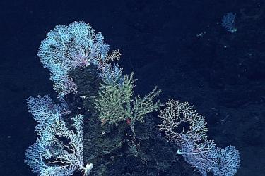
Deep-Sea Corals Results

48 results match your filter criteria.

Comparative Observations of Current Flow, Tidal Spectra, and Scattering Strength in and Around Hawaiian Deep-Sea Coral Patches

Environmental conditions of deep-sea corals were monitored to reveal patterns that can be considered in relation to what is known about the life history of deep-sea corals and how they might influence community settlement, growth, and diversity.
May 15, 2020 - Peer-Reviewed Research ,

Omnibus Deep-Sea Coral Amendment

This final rule designates coral protection areas on Georges Bank and in the Gulf of Maine and prohibit the use of certain bottom-tending gears in these areas. This action: Establishes a deep-sea coral protection area called the Georges Bank Deep…
Effective
04/28/2024

Lava Flow Time Portals: Understanding the Development of Deep-water Coral Communities

Researchers used lava flows to measure the growth rates of precious corals.
December 11, 2019 - Feature Story ,
750x500-lava-flow-PIFSC.jpg

Rock, Coral, Sponge: Does One Beat The Rest As Fish Habitat?

Rockfish love structure. More seafloor structure means more rockfish.
July 17, 2019 - Feature Story ,
AFSC-Rock_Coral_Sponge-Article (1).jpg

Cape Lookout Lophelia Banks Deepwater Coral HAPC Fishery Management Area Map & GIS Data

Map and GIS data representing the Cape Lookout Lophelia Banks Deepwater Coral Habitat Areas of Particular Concern (HAPC) in the South Atlantic Region.
June 27, 2019 - Map ,
CapeLookout.jpg

Cape Fear Lophelia Banks Deepwater Coral HAPC Fishery Management Area Map & GIS Data

Map and GIS data representing the Cape Fear Lophelia Banks Deepwater Coral Habitat Areas of Particular Concern (HAPC) in the South Atlantic Region.
June 27, 2019 - Map ,
CapeFear.jpg

Stetson-Miami Terrace Deepwater Coral HAPC Fishery Management Area Map & GIS Data

Map and GIS data representing the Stetson Reefs, Savannah and East Florida Lithotherms, and Miami Terrace (Stetson-Miami Terrace) Deepwater Coral Habitat Areas of Particular Concern (HAPC) in the South Atlantic Region.
June 27, 2019 - Map ,
Stetson_Miami.jpg

Pourtales Terrace Deepwater Coral HAPC Fishery Management Area Map & GIS Data

Map and GIS data representing the Pourtales Terrace Deepwater Coral Habitat Areas of Particular Concern (HAPC) in the South Atlantic Region.
June 27, 2019 - Map ,
Pourtales.jpg

Blake Ridge Diapir Deepwater Coral HAPC Fishery Management Area Map & GIS Data

Map and GIS data representing the Blake Ridge Diapir Deepwater Coral Habitat Areas of Particular Concern (HAPC) in the South Atlantic Region.
June 27, 2019 - Map ,
BlakeRidge.jpg

Shrimp Fishery Access Areas Fishery Management Areas Map & GIS Data

Map and GIS data representing shrimp fishery access areas in portions of the Stetson-Miami Terrace Deepwater Coral HAPC in the South Atlantic Region.
June 27, 2019 - Map ,
shrimp_AA.jpg